Environmental Engineering Reference
In-Depth Information
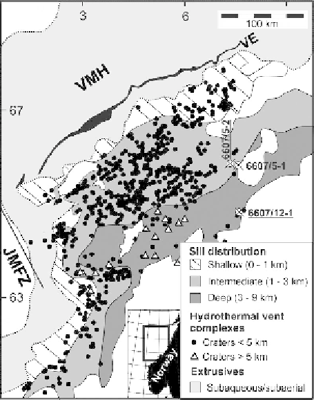
Figure 12.6 Extrusives (basalt
flows and hyaloclastites), sills and HVCs in the
Vøring Basin, offshore Norway. The sills and pipes were formed during emplace-
ment of the NAIP during the PETM. Abbreviations: VE: Vøring escarpment.
VMH: Vøring margin high. JMFZ: Jan Mayen fracture zone.
12.2.3 The NAIP and the Vøring and Møre basins
The Vøring and Møre basins offshore Norway contain a voluminous magmatic
complex of dominantly subhorizontal sills that intruded Cretaceous sedimentary
rocks during the opening of the northeast Atlantic (Planke
et al
.,
2005
; Cartwright
and Møller Hansen,
2006
). The sills cover an area of more than 80,000 km
2
offshore mid-Norway, and stacks of two to
five sills are commonly present in
the basins (
Figures 12.6
and
12.7
). Sill intrusions are identi
ed as high-amplitude
re
ections, commonly displaying saucer-shaped geometries (
Figure 12.7b
).
More than 700 HVCs have been mapped, and several thousand vent complexes
are likely present in these basins. In this marine setting, the craters of HVCs can
reach a size of more than 10 km in diameter (Planke
et al
.,
2005
). The HVCs
commonly have an eye-shaped geometry at the top Palaeocene palaeo-surface
(
Figure 12.7b
). The base of the semi-circular eye structures are crater
oors, as
documented by an industry borehole drilled through an eye structure (Svensen