Environmental Engineering Reference
In-Depth Information
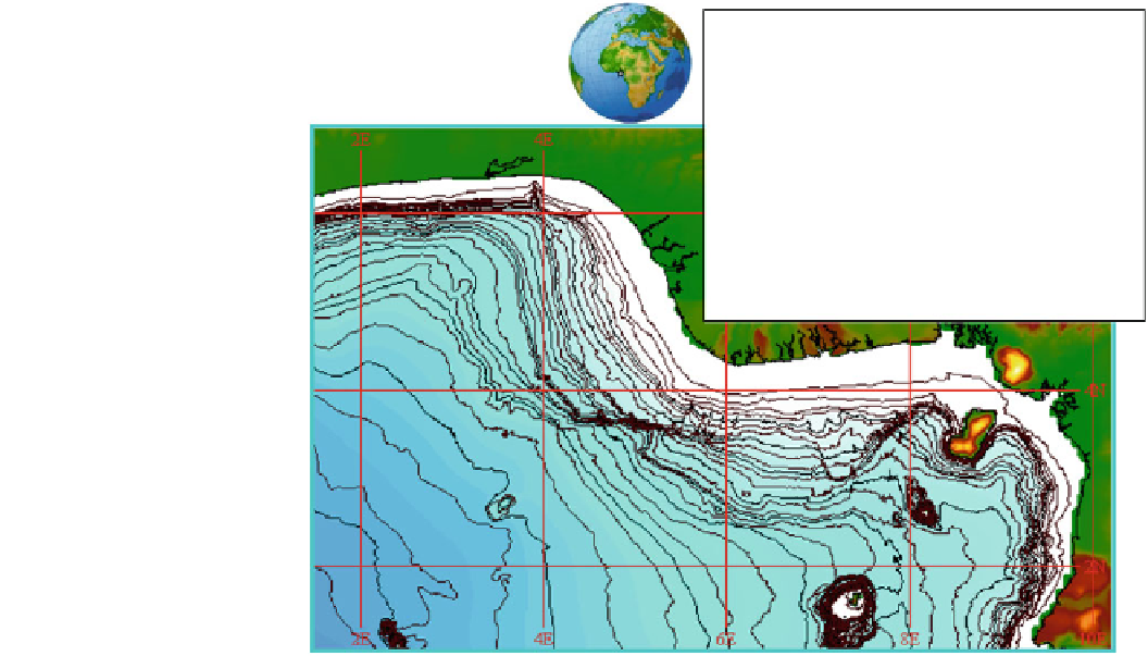
Fig. 1
Map showing the Niger
Delta, estuaries, and offshore
bathymetry
B - BENIN RIVER BR - BRASS RIVER
F - FORCADOS RIVER ST - ST NICHOLAS
RIVER
E - ESCRAVOS RIVER
SB - SANTA
BARBARA RIVER
R - RAMOS RIVER SO - SOMBEIRO
RIVER
D - DODO RIVER NB - CALABAR
RIVER
P - PENNINGTON RIVER BN - BONNY RIVER
DI - DIGATORO RIVER AN - ANDONI
K - KULAMA RIVER IM - IMO RIVER
FT - FISHTOWN RIVER K -
Avon Canyon
Mahin Canyon
B
F
E
R
DI
K
FT
KWA IBOE
C
K
50
IM
S
N
B
SB
N
ST
1000
Calabar Canyon
100
200
sea. The edge of the tidal swamps moves seaward as the back
of the barrier bar is eroded. The sub-aerial delta is nearly eight
times larger than the sub-aqueous delta, probably as a result
of the relatively high near-shore wave action and the presence
of strong littoral currents.
Table 1
Estimated areas occupied by selected environment, in pres-
ent day Niger Delta (After Whiteman
1982
)
Environment
km
2
Onshore and offshore total
160,930
Onshore 'fossil' delta complex
128,744
Upper and lower floodplains
5,219
Mangrove swamps
3,058
Continental Shelf
Barrier Islands
1,117
River mouth bars
993
The continental shelf off the Niger delta can be divided into
an inner shelf comprising of bathymetric configurations
parallel to the coastline with depths ranging from 0 to 45 m
(Fig.
1
). The middle shelf depths range from 45 to 80 m are
indented with gullies and terraces (Allen
1965
). The outer
shelf, with depths above 80 m, is also terraced and has
gradual slopes. There are other smaller gullies, especially off
the nose of the Niger delta within the middle to outer shelf
and the slope. The Avon and Mahin canyons are located west
of the Niger Delta while the Calabar canyon (Fig.
1
) is east of
the Delta (Allen
1965
; Burke
1972
; Awosika and Ibe
1994
).
Delta front platform
2,795
Pro delta slope
4,846
Open shelf (to shelf break)
6,214
Continental slope (Shelf break to 1,80 m)
9,941
Total (Onshore to Offshore to 1,280 m)
323,857
brackish waters, numerous creeks and creeklets, marshes, and
mangrove. The barrier bar complex consists of the modern
active beach and sand ridges developed in relation to older
strand lines. Intertidal coastal plain extends behind the barrier
bars and comprises tidal flats and swamps with dense man-
grove vegetation which alternate with tidal distributary
channels and lagoons. The plants are mainly halophytic red
mangrove (Rhizophora racemosa) characterized by breathing
roots, growing above the surface of the organically rich but
oxygen-depleted muds. Barrier beach islands, commonly
broken through by tide, separate the swamps from the open
Oceanographic Conditions
Oceanographic parameters that control circulation patterns
in estuaries and ocean consist of waves, tides and longshore
currents, with wind and salinity modifying these oceano-
graphic processes.


Search WWH ::

Custom Search