Environmental Engineering Reference
In-Depth Information
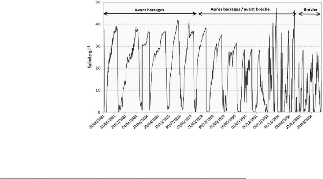
Fig. 8
Evolution of the salinity
range in St. Louis from 1981 to
2006
Table 1
Rates of salinity in the Senegal River in St. Louis in 2003 and 200
Years
Maximum
Minimum
Number of days of zero salinity
Salinity (g l
-1
)
Salinity (g l
-1
)
Date
Date
2003
17.8
May 21
0.48
July 15
129
2004
26.3
May 31
0.208
July 30
52
Source St. Louis Regional Service of Hydraulics
(upstream) and Diama (downstream) dams (Fig.
8
) but with
the volumes of water much higher. However, the general
trend of the change of surface salinity in St. Louis has been
on the rise since the opening of the channel.
Salt is present in the estuary most of the year, due to the
proximity of the sea and tidal effects which are dominant
compared to freshwater from the Senegal River, the result
being that the river is salty almost throughout the year
(Table
1
). Indeed, the number of days where the salinity is zero
more than halved between 2003 and 2004, from 129 to 52 days.
Some measurements of water quality conducted in some
wells in the Gandiolais region between 2005 and 2012 show
increasing trends of salinity in groundwater, already affected
by residual salt of geological origin. In villages located in the
lower estuary, lower freshwater inflows have caused enormous
difficulties in water supply for local populations, which are
now seriously threatened by a drastic reduction in freshwater
sources despite the programme of water purification units
installed in several locations in the Senegal River estuary.
Exploitation of salt in the Gandiolais dates from the late
nineteenth century, the salt resulting from marine trans-
gressions during the Quaternary, in particular during
Inchirian and Nouakchottian periods. During the with-
drawal of the sea, the evacuation of the marine deposits was
not entirely realized because of topographical and climatic
factors. The marine deposits thus accumulated in the lower
estuary and caused salinization of land.
Today, the boom in the exploitation of salt provides the
best indicator of salinity in the estuary. Salt extraction is
practiced mainly by women, in the Gandiolais region, par-
ticularly Tassinere, Mouit and Ndiebene Gandiole, around
the basin of Ngaye-Ngaye, tributary of the basin of Gue-
umbeul, where the salinity rate generally exceeds 35 g l
-1
at
the beginning of winter (Corea
2006
).
The volumes of salt produced have increased steadily
over the past ten years that is since the opening of the
breach and especially since the closure of the old mouth,
which turned into a lagoon since 2005 and operates almost
like a salty swamp. The size of salt farms gives a clear
indication of the presence of salt in the estuary (Fig.
4
).
This salt mining can be seen as an adaptation attempt of
local communities to degradation of environmental condi-
tions. However, the development of this salinization now
paralyses the market-gardening activities which are reduc-
ing and could even disappear. As an alternative, the popu-
lation shifted their activities, when possible, to areas less
affected by the salinization. Is this a sign of a developing
resilience of these communities of Gandiolais? Only
socioeconomic studies and surveys can provide an answer
to this fundamental question (Photo
4
).


Search WWH ::

Custom Search