Environmental Engineering Reference
In-Depth Information
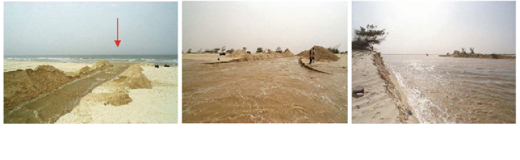
The breach
The breach
The breach
04/10/2003
after 1 week
1 month after
Photo 2
Progression of the gap between October and November 2003 (Photos 1. Diop, 2003)
of the Diama dam were forced to allow releases to the lower
estuary, contributing to raising the water level in the Sen-
egal River.
The vulnerability of the city of St. Louis to floods is
related to physical, human and organizational factors: (1)
the city is built on a site with very low topographic heights,
barely exceeding 3 m except in dune areas where altitudes
can reach 10 m; (2) building on the flood plain, which is
characterized by important deposits of muddy sediments,
prevents proper drainage of large floods; (3) urban planning
did not allow for the constraint represented by the river—
the long-lasting drought since the 1970s had virtually
removed flooding from the list of urban risks. Other factors
such as lack of dredging of the river channel and from the
river mouth to the city of St. Louis provide a better
understanding the exposure of the lower estuary to the
recurrent floods which it has experienced in recent years.
To limit this threat and protect St. Louis and its heritage,
the government of Senegal decided to open a breach in the
Langue de Barbarie on the night of 3-4 October 2003. The
main objective of this action was to rapidly release the
floodwaters that threatened the city. The gap thus formed
lowered the water level from 1.95 to 1 m IGN, with dis-
charges of 100 m
3
s
-1
at the opening.
This particularly severe action was decided and executed
without preliminary study of the potential impacts or any
accompanying measures to mitigate their effects in the
longer term.
The idea of opening a breach in the Langue de Barbarie
and/or dredging the mouth is not new; several authors and
studies suggested it since the early nineteenth century.
Studies of the seaworthiness of the Senegal River led by
Cosec (
2002
) also recommended digging a channel for
improving the navigation and security of crossing the bar.
Modelling studies conducted within the framework of an
Integrated Coastal Area and River Management Programme
in 2001-2002 under the supervision of the Water Ministry
proposed, among other solutions, the opening of a channel
with floodgates at about 5.5 km south of St. Louis. The
effectiveness of the channel was to be improved by dredg-
ing the river channel to allow faster drainage. These studies
have clearly not been taken into account.
Spatial and Temporal Evolution of the Breach
The breach in the Langue de Barbarie was opened about
7 km south of St. Louis, on the night of 3-4 October 2003.
Its initial dimensions were 4 m broad and 100 m length,
with a depth of 1.5 m (Photo
2
). The decision to open the
breach was made by high-ranking government authorities.
From the early hours of its opening, the breach fully met
expectations with the creation of a hydraulic head and a
breaking of the sand spit whose effect was to rapidly drain
the estuary and thus preserve the city of St. Louis from
flooding. The water level in St. Louis fells from 1.95 to 1 m,
nearly 50 %, in 26 h.
The rapid evolution of the breach, under the combined
effects of the swell and longshore drift, is still a concern,
justifying the various monitoring performed by the Regio-
nal Water Resources Services and the Department of
Geography of Cheikh Anta Diop University between
October 2003 and July 2008. With a width of 200 m, the
discharge flow rate stood at 1,906 m
3
s
-1
on 6 October
2003. On October 23, the breach was 329 m wide and the
discharge flow rate was 1,968 m
3
s
-1
. In December 2003,
the width was 490 m.
The initial width of 4 m increased rapidly to 1,300 m in
one year and then to 1,700 m in July 2008, according to
bathymetric measurements carried out regularly by the
Regional Services Hydraulics St. Louis (Kane et al.
2011
).
In
addition
to
widening
rapidly,
the
gap
also
quickly


Search WWH ::

Custom Search