Environmental Engineering Reference
In-Depth Information
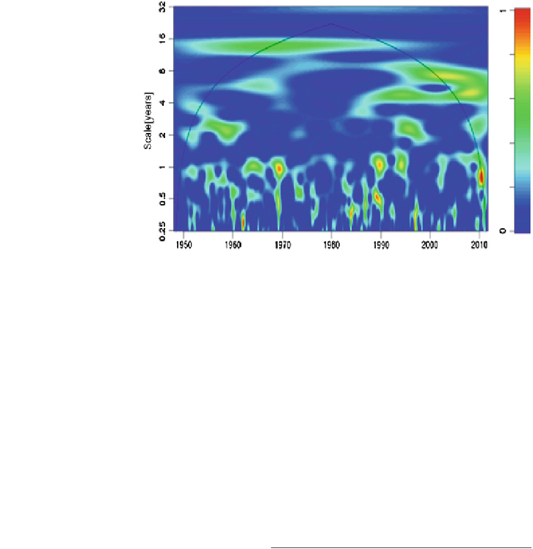
Fig. 2
Wavelet analysis of zonal
wind fields from the ERA40 data
(Courtesy to Massei N., M2C
Rouen)
Barbarie is home to about 24 % of the population of the city
of St. Louis.
Maps and historical documents have been used to trace
the evolution of the mouth since 1658 and set a periodicity
of 14 years for breaks around the Langue de Barbarie and
the maximum penetration of the tide into the estuary
(Rochette
1974
). This periodicity seems perfectly correlated
with the results of an analysis of zonal wind fields from the
ERA40 climate reanalysis data, which also show a cycle of
between 12 and 16 years, observable until the early 1990s
(Fig.
2
), coinciding with the start-up of the Diama and
Manantali dams. This change in the 1990s was also recor-
ded in the Maghreb, including Morocco, Tunisia and
Algeria (Massei et al.
2007
; Laignel et al.
2010
; Louamri
et al.
2011
).
So since 1973, no significant breakdown of the Langue
de Barbarie has been detected; the Senegal River mouth has
steadily migrated south (Fig.
3
), carrying with it the littoral
spit which has neither been widened nor grown since its
formation (Diouf and Kane
2002
). The continuation of this
southern trajectory implies the mobilization and deposition
of sediments on the northern edge and the erosion of the
southern edge of the spit. Indeed, the Langue de Barbarie is
a sedimentary transit area of North-South direction. The
estimation of sedimentary transport on the external shore,
carried out according to various methods and by several
authors, gives values between 1.5 million m
3
year
-1
and
365,000 m
3
year
-1
(Minot
1934
; Riou
1936
; Surveyer,
Nenninger & Chenevert
1972
; Pinson-Mouillot
1980
; Sall
1982
; BBL/SW et al.
1985
). Based on topographical sur-
veys
estimates made by Kane (
1985
and
1997
) reported an
annual average volume of approximately 600,000 m
3
of
sediment transported annually to the forefront of the Langue
de Barbarie. More detailed estimates by Barusseau (
1980
)
give values between 223,000 and 495,000 m
3
year
-1
for
mobilized materials of dimension varying between 0.1 and
0.5 mm.
On the internal shore, corresponding to the river sector,
suspended sediments were estimated, in particular by Kane
(
1985
and
1997
) and the EQUESEN programme (
1993
).
Flows of continental origin transiting to the river mouth
were 725,000 tonnes for the period 1989-1990. This dis-
charge of continental sediments is in the form of a turbid
plume, very characteristic of the Senegal River mouth
(Fig.
3
). According to Michel et al. (
1993
), the sediment
load varies between 10
6
tonnes in low flood to 2.8 10
6
tonnes in very high flood. These suspended sediments are
composed mainly of clay (92 %), fine silt (6 %) and coarse
silt (2 %).
The Breach of the Langue de Barbarie
The first years of the Diama dam resulted in profound
changes, both morphological and hydro-chemical, in the
lower estuary, the operation of which was strongly altered.
The dam became the artificial boundary upstream of the
estuary while the limit downstream remained the mouth, a
unique outlet where sea water can go back into the river
(Kane
1997
). The Manantali dam completion in 1988
contributed to the complexity of the system. In addition to
and
annual
average
lengthening
southward,
the
Search WWH ::

Custom Search