Environmental Engineering Reference
In-Depth Information
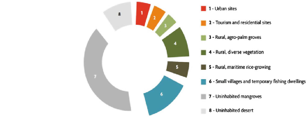
Fig. 1
Distribution (percentage
of the coastline) of different
forms of human land use in the
first kilometre from the coastal
strip inwards—the high
percentage of mangroves is
related to the high fractal
dimension of the shoreline along
these seaboards (SDLAO,
UEMOA-IUCN
2011
)
Abidjan, which is said to have an abnormally low rate of
space consumption, is not included.
situation, where corridor concentration is sometimes
weighted (except in the case of the Dakar peninsula) by a
regular and relatively balanced road grid with tentacles
stretching towards the different expanding secondary towns.
Apart from the situation of the consolidated districts
(historical, partly) of urban centres, the dynamics of
extension to peri-urban areas or areas in proximity to the sea
is organised succinctly around for basic types:
• Extensions related to industrial activities, with, in par-
ticular, the attractiveness of harbours, which constitute
business and investment centres.
• Precarious (or random) residential districts close to the
centres and often located in areas highly exposed to risks
and often historically unoccupied.
• Peri-urban extensions for residential purposes (seaside
residences) or tourism, often along the main coastal
roads, on north sides of the main agglomeration, the rapid
development
The AFRICAPOLIS report states: ''The average density of
agglomerations did not increase from 1950 to 2000 as far as we
can estimate in the current state of our work based on a sample
of 97 towns for which we have the surface area in 1960. This
sample accounts for 1/9th of the total agglomerations with
populations of more than 10,000 in West Africa but 44 % of the
urbanised land. This primarily concerns the largest agglomer-
ations… Between 1950 and 2000, the urbanised area of our
sample increased from 766 to 6,381 km
2
, the average annual
extension of urbanised land was therefore 5.1 % compared to
4.3 for the population.''
Spread: The first thing that stands out about the growth
of agglomerations is the horizontal spread of built-up areas,
with the evident consequence of considerable land use,
rising cost of facilities (roads, power, sanitation, etc.),
accentuated by the often low-lying, flat topography of the
littoral areas occupied by coastal agglomerations. These are
often situated on the edge of a lagoon, in situations that
complicate the collection and evacuation of waste waters
and rainwater... Spread is often also responsible for the
''exiling'' of population groups in a precarious economic
situation to peripheral areas far from the centre. Note that
the historical
of
which
often
follows
speculative
dynamics.
• The fishermen's districts located very close to the shore
and canoe
landing areas, in more or less precarious
settlements.
These urban developments also imply the mobilisation of
building materials leading to extractions and quarries on
natural sites. The extraction sites are logically located as
close as possible to the sectors being extended and concern
fragile coastal formations, such as dune rims, for the
extraction of sand. In other cases, rocky materials are
employed either in blocks, or crushed, as is the case in Togo
for the beach rock freed by erosion, an effective natural
protection for a coast that is under threat, today subject to
exploitation. Generally, regulatory measures eventually ban
the practice, but either these come late or they are difficult
to apply as long as viable economic and environmental
alternatives have not been identified and possibly accom-
panied by public action.
centres
of
the largest
agglomerations
are
typically located in proximity to the sea front.
Corridorisation: Agglomerations usually spread in cor-
ridors following the busiest communication routes. This
corridor development can take on considerable dimensions
in some cases, evolving into a long conurbation, as is the
case between Keta (in Ghana) and the border with Togo, or
between Lomé and Cotonou, in both cases along the coastal
interstate road. In the case of Ghana, the model differs
somewhat, with a mesh of ''micro-centres'', hub crossroads
and small agglomerations in satellite positions around the
major cities. These growth centres have a tendency to join
up in the long term. In Senegal, there is an intermediate
Search WWH ::

Custom Search