Travel Reference
In-Depth Information
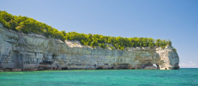
The awe-inspiring sandstone cliffs that rise up dramatically from Lake Superior in Pictured Rocks National Lakeshore
are best seen by boat, although hiking trails and scenic overlooks provide access for land dwellers.
5.
Pictured Rocks National Lakeshore
From the Manistique area the drive pushes north on Rte. 94, crossing the peninsula and
arriving at the little city of Munising, the gateway to Pictured Rocks National Lakeshore.
Extending for some 40 miles along the shore of Lake Superior from Munising to Grand
Marais, this arresting wilderness area contains a wealth of multihued sandstone cliffs; fort-
resslike rock formations; windblown forest; bright, sandy beaches; and impressive dunes.
Hiking trails abound in this stretch of lakeshore paradise, the most traveled being the
Lakeshore-North Country Trail, which hugs the coast for the entire length of the park.
Two spots along the trail are as rewarding as they are accessible (you can drive to
each via back roads if you prefer to spare your feet). One is Miners Beach, where a lovely
stream,formingawaterfallandanidylliclittlelake,emptiesintoLakeSuperior;themouth
ofthestreamisflankedbythenine-story-highMinersCastletothewestandaveryinviting
sandy beach to the east. Stand on the cliffs to have the best view. The other choice spot is
Chapel Basin, a day-hiker's dream that invites leisurely exploration of its streams, ponds,
waterfalls, beaches, and high cliffs.
For the most dramatic and revealing views of the red, green, blue, and white Pictured
Rocks, get out into the lake. Between mid-May and October, excursion boats depart daily
from Munising to tour the colorful cliffs.
Search WWH ::

Custom Search