Environmental Engineering Reference
In-Depth Information
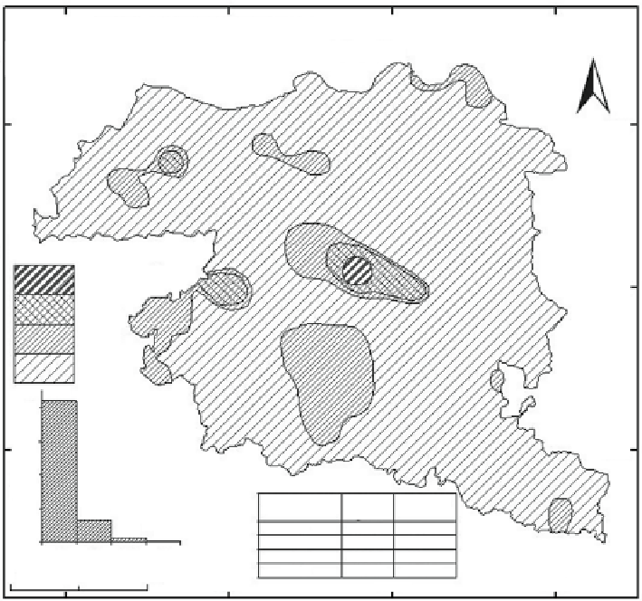
RELATIVE RELIEF
Ausgram Block I & II Burdwan District
N
23
35'N
Relief in Meter/Sq.km
> 9
23
30'N
6 - 9
3 - 6
< 3
84.14
80
60
23
25'N
40
Relative Relief
Area in
Sq.km
Area in %
20
12.75
<3
3 - 6
414.60
063.05
013.28
002.07
84.14
2.69
0.42
0
12.75
< 3
3-6
6-9
> 9
6 - 9
>9
02.69
Relative Relief
00.42
0
4
8
Km
87
35'E
87
40'E
87
45'E
Fig. 3
Relative relief map (
Source
: 73 M/10, 11, 14 & 15)
Drainage Density (DD)
Drainage density is defined as the total length of streams/km
2
. Density factor is related
to climate, rock type, relief, infiltration capacity, vegetation cover, surface roughness
and run-off intensity index. The drainage density explains the stage of fluvial eroded
landscape. The importance of drainage density analysis is due to two reasons. Firstly,
it reflects the potential rate of discharge of water to be transmitted through the respec-
tive region or basin and secondly, it reflects climatic conditions of particular area. The
drainage density indicates the closeness of spacing of channels (Horton
1932
).
Lu
A
()
=
Drainage
density
D
where
Lu
is total length of stream channels per unit area (km) and
A
is area of the
unit (km
2
) (Horton
1932
).
Search WWH ::

Custom Search