Geoscience Reference
In-Depth Information
b
a
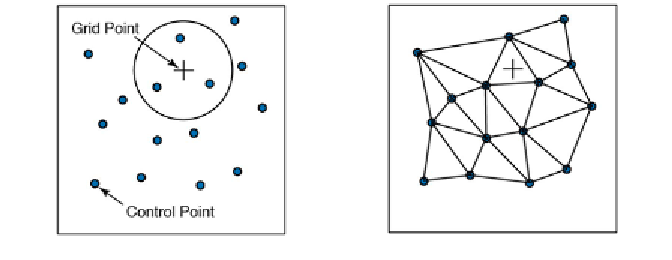
Fig. 7.5
Methods for selecting the control points to use for estimating the values at grid
points.
a
Construction of a circle around the grid point (plus sign) with a radius dei ned by
spatial autocorrelation of the
z
-values at the control points (small circles).
b
Triangulation: the
control points are selected from the vertices of the triangle surrounding the grid point, with
the option of also including the vertices of the adjoining triangles.
needs to be estimated for the
grid points
. Control points are the unevenly-
spaced i eld measurements, such as the thicknesses of sandstone units at
dif erent outcrops or the concentrations of a chemical tracer in water wells.
h e data are generally represented as
xyz
triplets, where
x
and
y
are spatial
coordinates and
z
is the variable of interest. In such cases most gridding
methods require continuous and unique data. However, spatial variables in
earth sciences are ot en discontinuous and not spatially unique: for example,
the sandstone unit may be faulted or folded. Furthermore, gridding requires
spatial autocorrelation, i.e., the neighboring data points should be correlated
with each other through a specii c relationship. h ere is no point in making a
surface estimation if the
z
variables are random and have no autocorrelation.
Having selected the control points, a number of dif erent methods are
available for calculating the
z
-values at the evenly-spaced grid points.
Various techniques exist for selecting the control points. Most methods
make arbitrary assumptions on the autocorrelation of the
z
-variable. h e
nearest-neighbor criterion
includes all control points within a circular
neighborhood of the grid point, where the radius of the circle is specii ed
by the user (Fig. 7.5 a). Since the degree of spatial autocorrelation is likely to
decrease with increasing distance from the grid point, considering too many
distant control points is likely to lead to erroneous results when computing
values for the grid points. On the other hand, using radii that are too small
may limit the number of control points used in calculating the grid point
values to a very small number, resulting in a noisy estimate of the modeled
surface.