Global Positioning System Reference
In-Depth Information
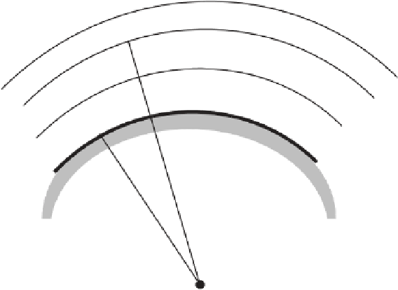
Satellite
d
m
d
u
φ
′
φ′
m
IPP
Ionosphere
h
φ
U
Earth
φ
m
M
M - Reference station position
U - User position
IPP - Ionospheric pierce point
R - Radius of the Earth
E
R
E
ψ
pp
Figure 8.7
Ionospheric delay difference.
p
d
p
d
403
.
Iono
Iono
ε
−
ε
=
⋅
−
cos
φ
′
⋅
⋅
TEC
u
m
m
f
2
m
m
100
km
km
403
.
≈−
⋅
cos
45
°⋅
⋅
50
×
10
16
(
)
4
2
210
×
9
1575
.
×
10
=
003
.
m
The variation of the ionospheric delay difference due to differences in elevation
angle as a function of separation is shown in Figure 8.8 for three values of satellite
elevation angle and a
TEC
of 50
10
16
electrons/m
2
.
Spatial variations in TEC within the ionosphere typically lead to much greater
differences in ionospheric delay than those attributable to elevation angle. The dif-
ference in vertical ionospheric delays (i.e., delays observed for a satellite that is
directly overhead) due to TEC gradients is typically in the range of 0.2-0.5m over
100 km when the ionosphere is undisturbed, but it can be greater than 4m over 100
km when the ionosphere is disturbed [6, 7]. Slant range delays during daylight hours
were evaluated in [8] for a network of GPS receivers over a 1-year time frame. The
conclusions from [8] were that the difference in ionospheric delays seen by two
receivers separated by 400 km in a midlatitude region is expected to be less than 2m
×


Search WWH ::

Custom Search