Biology Reference
In-Depth Information
cades or waterfalls. A roar would have filled the air as the melt-water from
faraway glaciers sent floods through the Golden Gate to the ocean. The
river cut deep channels into the bedrock at the Carquinez and Raccoon
Straits, turning the tip of the Tiburon Peninsula into an island that became
Angel Island. The river also carved a canyon through the Golden Gate.”
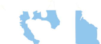
The series of bedrock ridges thrust up between the Pacific and the Cen-
tral Valley bestowed upon the estuary its unusual hourglass curves. They
also gave it a unique river delta, many miles inland from the sea. Before
the watershed's rivers cut the Carquinez Strait, the sediments they carried
had been backing up for thousands of years behind the Carquinez Hills.
The material accumulated at the confluence of the Sacramento and San
Joaquin rivers and eventually formed the 540-square-mile marsh of the
historic delta.
According to Sloan, “Until about three million years ago, rivers that
drained into the Central Valley flowed southward to an ocean outlet down
near the San Joaquin Valley's Kettleman Hills. As the valley slowly emerged
from the sea and movement along the San Andreas fault closed off this
southern outlet, a lake formed in the Central Valley.” The lake swelled and
shrank with the ice ages, but eventually it broke through the coastal hills at
15,000 years ago
End of last Ice Age—sea level
approximately 400 feet below
present level; rivers not shown
10,000 years ago
Formation of Farallon Islands
and intrusion into the “Golden
Gate”
5,000 years ago
Formation of Bay and Delta
Basins
125 years ago
Landward edge of undiked
tidal marsh
Today
Includes changes due to
hydraulic mining sediment
deposition, land reclamation,
and filling of wetland areas
Figure 1. Marine water intrusion into the Central Valley created today's bay and
delta. (The Bay Institute, Courtesy of CALFED)