Agriculture Reference
In-Depth Information
4.6
Near-Real-Time Remote Sensing
Satellites and piloted aircraft-based remote sensing systems are the two major plat-
forms that have been commonly used to collect remote sensing image data. Current
limitations for the conventional image-based remote sensing platforms are due
mainly to coarse spatial resolution, slow turnaround time, inadequate repeat cover-
age, and high cost [
20
,
21
,
27
]. Most importantly, since agriculture is very dynamic,
remote sensing data must reach the farmer in near real time. However, this is rarely
the case now [
28
]. Sawyer et al. also pointed out that the biggest diffi culty in imple-
menting variable-rate technology (VRT) is the lack of a reliable and consistent
method of obtaining spatial and temporal variability data from a fi eld [
29
]. To deal
with the problems that exist in current remote sensing platforms for biomass prehar-
vest monitoring, near-real-time remote sensing is necessary and subsequently needs
to develop site-specifi c monitoring for biomass energy crops.
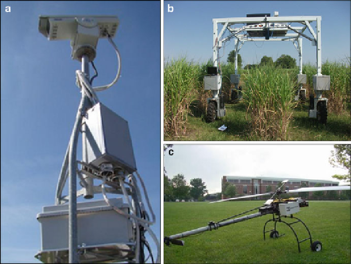
As indicated in Fig.
4.5
, three near-real-time site-specifi c remote sensing sys-
tems for biomass preharvest monitoring are possible: (1) stand-alone tower-based
Fig. 4.5
Near-real-time remote sensing system for biomass energy crop site-specifi c monitoring.
(
a
) Tower. (
b
) Ground reference data collection vehicle. (
c
) UAV-based remote sensing
Search WWH ::

Custom Search