Geoscience Reference
In-Depth Information
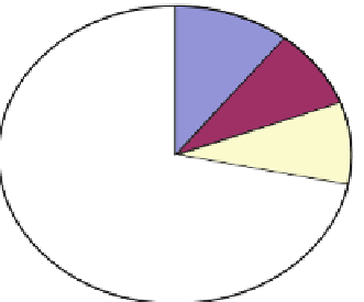
11%
9%
33%
Non-existent
Conceptual
Infancy
Growing
Mature
9%
38%
Fig. 9.3 Current use of GIS
question asked about the improvements they would like to see to their GIS
capabilities. Thirty-one responded to this question. Some responses included better
hardware, software, and more training, better understanding of what is being
created, knowledge behind constructing and using model builder, easier interfaces
with spatial statistics, and being able to acquire the most recent data.
9.5.3 Spatial Data Resources
Forty-four individuals responded to two questions on spatial data resources. The
first question displayed several websites that can be used to access GIS data. The
participants were asked to mark all sites that they have used to acquire data
(Fig.
9.4
). Twenty-eight respondents (63.6 %) used Ohio Department of Natural
Resources (ODNR) Geographic Information Management Systems (GIMS) to
access data. Twenty-one respondents (47.7 %) used Natural Resource Conservation
Service (NRCS) Data Gateway. Only six respondents admittedly purchased data
from vendors. Three responded to not using any of the sites mentioned. The second
question presented data themes and asked which themes they used. Three data
themes were the most prevalent with each being selected by 32 respondents
(72.7 %). These included orthoimagery (aerial photography, satellite images,
etc.), hydrography (rivers, streams, lakes, wetlands, watersheds, etc.), and environ-
mental (soils, habitats, etc.). The data theme that was used the least was public
safety/public health, which was only used by 29.5 % of respondents.
9.5.4 Maumee Basin Online GIS
The participants were asked to view and manipulate the Online GIS viewer located at
www.maumee.utoledo.edu
. Thirty-four responded to this set of inquiries. The first