Geoscience Reference
In-Depth Information
www.maumee.utoledo.edu
. The participants were asked to explore the viewer
and answer questions about what data and tools they utilized in their exploration.
They were also asked to rate the viewer in terms of its relevancy to their work.
The fourth section asked a few open ended questions about data distribution,
data sharing, and data exchange. The importance of this information is to see
how participants are collaborating with other users and to see if they are utilizing
GIS user group activities that are currently being offered in their area.
The final group of questions asked about participants' future use of GIS.
Are they planning on using the Maumee Basin Online GIS website and online
viewer for their watershed planning? How they will use it or why they wouldn't use
it? What type of mapping needs does their organization foresee in the future and
what other datasets would be useful to have available? These responses will help
determine what the overall consensuses of needs are and where they see their group
going as far as GIS capabilities.
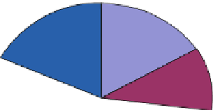
9.5 Results
The key results of the web-based GIS watershed survey are provided. The invitation
to participate in the research attracted 55 responses from 188 people contacted
(29 % return rate). Of the 55 respondents 11 were from University or nongovern-
mental organizations, 10 were from the city government, 9 were from the federal
government, 5 were from consultant or contracting companies, 4 were from
the county government and 10 were from “other” groups which included the park
district, school system, local/township government, volunteer, and retired engineers
(Fig.
9.2
).
16%
18%
Federal Government
State Government
County Government
City Government
NGO or University
Consultant or Contractor
Other
11%
9%
7%
21%
18%
Fig. 9.2 Employment of respondents