Environmental Engineering Reference
In-Depth Information
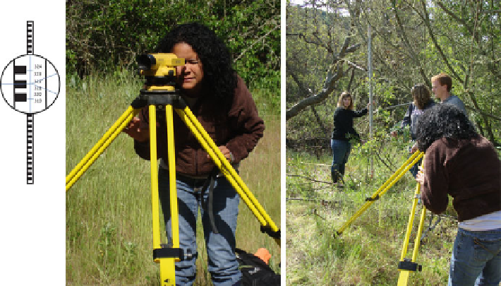
Fig. 2.10 Autolevel surveys are a series of “shots” in which a rod reading is recorded. The colored
blocks are 0.01 m tall, and every 0.01 m has a number. This shot indicates that the ground elevation
is 3.215 m below the optical center or instrument height (HI) of the scope
recommend using a tape grid for positioning. Once a horizontal grid is established
(see previous section), the scope and tripod can be set up as close to the wetland as
possible, but with a clear view of all points to be surveyed. The tripod might need to
be set up multiple times in different locations if the wetland is large, or if the line of
sight is limited. Moving the scope requires the use of a “turning point” in the survey
to keep the autolevel scope in the original vertical reference frame. In some
wetlands, the canopy may be so dense that the use of a scope is impossible. As a
substitute, a compass can be used to obtain direction, and a measuring tape can be
used to determine the horizontal distance from a known location.
The autolevel is convenient not only because it can measure ground surface
elevations beyond the water surface, but also because it can be used under any
wadeable condition. The autolevel is an optical telescope with crosshairs that is
mounted on a tripod and provides a level view no matter where it is pointing
(Fig.
2.10
). The scope person views a leveling rod held vertically by the rod person,
and records the elevation value indicated by the intersection of the horizontal, center
crosshair, and an elevation value marked on the rod (Fig.
2.10
). Each reading of the
rod is called a survey “shot.” Shots are simply measurements between the ground
where the rod is placed and the optical center of the scope, indicated by the horizontal
cross hair (Fig.
2.10
). The standard notes for an auto level survey are shown in Fig.
2.5
.
The basic autolevel set up includes the following steps. First, a surveyor must
find a location where the instrument has a clear view of the wetland to be surveyed
as well as any benchmarks that will be used to vertically control the survey. Next,
the tripod feet must be firmly set so that the tripod top height is at a comfortable
viewing elevation and the mounting bracket is approximately level. Then, the