Environmental Engineering Reference
In-Depth Information
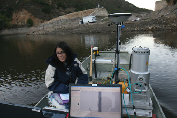
Fig. 2.2 Graduate student operates a vessel-based terrestrial LiDAR unit as she creates a precise
digital elevation model of the Los Padres Reservoir in the Carmel River watershed (Published with
kind permission of
©
Rikk Kvitec 2014. All Rights Reserved)
(Fig.
2.2
). Of course, some wetlands have special constraints. For example, quaking
bogs are challenging because a portion of the water column is inaccessible from the
surface, and might require the use of sonar or SCUBA.
Each survey involves collecting the position (X, Y) and elevation (Z) of a
number of points on the landscape. The surveying equipment available to collect
these data includes measuring tapes, meter sticks, lead lines, stadia rods, survey
levels, laser levels, handheld GPS, total stations, survey grade GPS, and both
ground-based and aerial LiDAR. A description of each type of equipment is
provided in Table
2.1
. The instrument selected will be determined by the factors
listed above. We present the survey techniques that are applicable to most wadeable
wetlands in order from simplest and least expensive to complex and most expen-
sive. We also provide a description of LiDAR technology, which is most suitable
for broad wetland environments such as estuarine tidal flats and large scale hum-
mocky environments without vegetation.
Once the data are collected, there are several software packages available for
creating maps from the raw data as well as conducting geomorphic analyses. Two
of the common professionally used packages are ESRI ArcGIS and Fledermaus.
Both are relatively easy to use. Fledermaus has more flexibility for rendering digital
hillshade models, which can export models that can be viewed and rotated in a
free viewer.
Defining the range of questions to be addressed in a survey of wetlands may help
determine the type of methods to be used. Although the relative accuracy is
important, other parameters should be defined. For example, will the field survey
work be repeated over time? If so, then it may be important to set up permanent
markers or benchmarks so the same transects can be used at a later date. Will the