Environmental Engineering Reference
In-Depth Information
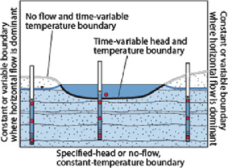
Fig. 3.28 Boundaries associated with a coupled water- and heat-flow model to simulate ground-
water exchange with a wetland in two dimensions.
Red dots
are locations where temperature is
measured. Head is measured at the wetland and at the screened interval of two monitoring wells
(Modified from Stonestrom and Constantz (
2003
). Published with kind permission of the
U.S. Geological Survey. Figure is public domain in the USA. All Rights Reserved)
Measuring and mapping the temperature of the submerged wetland bed also can
be used to determine rates and distribution of groundwater discharge, but only for
wetlands where groundwater discharge is prominent and pervasive (Schmidt
et al.
2007
). This method uses the Turcotte and Schubert (
1982
) solution for
steady-state 1-dimensional advection-diffusion heat flow and relates temperature
measured at about 20-cm depth in the bed sediment to an assumed constant
temperature at greater depth in the sediment. The method requires that the
surface-water temperature has small diurnal variability prior to and during the
mapping of the temperature of the wetland bed, a condition best met during winter
or during prolonged cloudy periods. Although the method was developed for use in
streams, it should provide acceptable results for many wetlands that receive
groundwater discharge; bed-sediment temperatures should be measured during
periods when diurnal fluctuations are minimal. The method should work particu-
larly well for wetlands that are ice covered during winter.
Mapping the bed temperature has become much easier with the growing use of
what is now commonly called the distributed temperature system (DTS) (Selker
et al.
2006
; Fleckenstein et al.
2010
). This system uses a device that sends a laser
pulse down a length of fiber-optic cable that can be up to several km long. The light
signal is reflected back to the sensor from every point along the cable. By timing the
return, and resolving the frequency distribution of the light scattering, temperature
can be determined to about 0.1
C resolution and averaged over cable increments of
0.5-1 m. Temperature mapping of a sediment bed can be done as frequently as
every minute to several minutes, allowing a qualitative determination of temporal
as well as spatial variability of groundwater discharge (e.g., Henderson et al.
2009
).