Environmental Engineering Reference
In-Depth Information
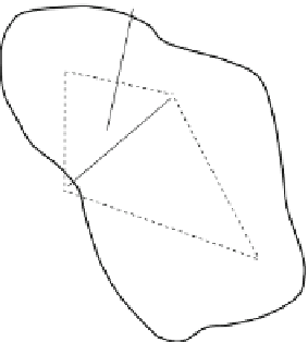
Fig. 3.7 Construction
of Thiessen polygons by:
Step-1, drawing the dashed
lines connecting adjacent
gages, Step-2, drawing solid
lines perpendicularly
bisecting the dashed lines,
and Step-3, dividing the area
into four polygons defined by
the solid lines
within and beyond the narrow storm track. For these reasons, precipitation gages
need to be located as close as possible to the wetlands being studied. Determining
precipitation over a large wetland or drainage basin of wetlands may require
multiple gages to capture spatial variability. If precipitation data from nearby
weather stations are used, instead of an on-site gage, errors resulting from spatial
variability should be considered carefully.
To estimate areal precipitation using data from multiple stations, or to estimate
local precipitation using data from distant weather stations, data need to be
interpolated spatially using one of several surface-fitting method (Dingman
2002
:118-130). The weighted-average method estimates precipitation (
P
av
)by
the sum of the product of individual station data (
p
i
) multiplied by a station-
specific weighting factor (
w
i
):
X
and
X
N
N
P
av
¼
w
i
p
i
w
i
¼
1
(3.6)
i¼
1
i¼
1
where
N
is the number of stations. The simplest averaging scheme is the arithmetic
mean that uses
w
i
¼
1/
N
for all stations. Another commonly used scheme is the
Thiessen polygon method, in which the area of interest is divided into
N
polygons
as shown in Fig.
3.7
, and
w
i
is given by the area of each polygon divided by the total
area. Other surface-fitting methods are more convenient for constructing precipita-
tion maps from a large or relatively dense network of gages. In these methods, the
area is divided into a large number of grid cells and precipitation for each grid cell is
computed from station data using a weighted average scheme similar to Eq.
3.6
.
The most commonly used weighting schemes include the inverse distance method,
where
w
i
is inversely proportional to the distance between the grid cell and the
station, and the kriging method, which assigns
w
i
based on geostatistical correlation
among station data (e.g., Kitanidis
1997
). These methods are available in popular
software packages such as ArcGIS (Environmental Systems Research Institute Inc.)
and Surfer (Golden Software Inc.). The software packages can be used to estimate
total precipitation over the area, or point values of precipitation for a location that
does not have a local precipitation gauge.