Environmental Engineering Reference
In-Depth Information
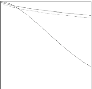
Fig. 3.6 Gage-catch
deficiency for rain and snow
as a function of wind speed at
the orifice height. Data are
for the U.S. National
Weather Service standard
8-in. gage with and without
Alter shields (equations
compiled by Dingman
2002
:111-112)
1
0.8
0.6
0.4
rain, Alter
rain, no shield
snow, Alter
snow, no shield
0.2
0
0
2
4
6
8
wind speed (m s
-1
)
to have a sufficient amount of antifreeze solution to melt incoming precipitation,
even at very low temperatures. If a heated tipping bucket gage is used, the effects of
evaporation due to heating need to be considered. During high-intensity snowfall,
snow may pile up at the gage orifice and subsequently blow off, causing negative
bias in measured precipitation. If a gage is located in an exposed area, drifting snow
may fall into the gage, causing positive bias.
Blowing snow causes redistribution of accumulated snow and substantial subli-
mation loss, resulting in large local-scale variability of snow density and accumula-
tion. Depending on the surface condition of a wetland and the surrounding upland, the
wetland may accumulate higher or lower amounts of snow than recorded by precipi-
tation gages. For example, if a wetland has a smooth-ice surface and the surrounding
upland is covered by tall grasses, much of the snow that falls on the wetland may drift
to the wetland edge or the upland, where it is trapped by grasses. On the other hand, if
a wetland is situated in a relatively deep basin and has extensive emergent vegetation,
snow may drift from the upland and accumulate in the wetland. For these reasons, it
often is better to quantify and distinguish between snow accumulation on the wetland,
and snow accumulation on the surrounding terrain, rather than trying to relate
snowfall measured with a precipitation gage to distribution across a landscape of
interest.
A snow survey conducted at peak snowpack accumulation, just before the
snowpack starts to melt, can integrate, both spatially and temporally, all of the
processes that apply and redistribute snow over a landscape, including drifting, loss
due to sublimation, and mid-winter melt events. A snow survey should be
conducted along an established line, called a snow course, that encompasses the
local-scale heterogeneity of landforms and vegetation across the area of interest.
At a fixed interval (typically 10-50 m) along the snow course, a snow tube is used to
measure the depth of snow and collect a sample for determining snow density by
weight. Depending on the scale of survey, the process can be abbreviated by
measuring depth at all of the sites and measuring density at a subset of those
sites. In this case, the depth-density relation needs to be established to estimate