Environmental Engineering Reference
In-Depth Information
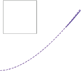
Fig. 3.3 Wetland area and
volume related to stage
based on a detailed map of
wetland bathymetry for an
irregularly shaped wetland.
D.O. Rosenberry unpublished
data for wetland P1,
Cottonwood Lake Area,
North Dakota
Area
Fitted area
Volume
Fitted volume
s
= 32331
p
= 2.75
Depth, m
A relation between wetland stage and surface area or volume is needed to
determine a volume associated with change in stage. If detailed bathymetry
data are available, curves relating wetland area and volume with stage can be
generated, from which wetland volume can be determined for any given stage
value (e.g., Fig.
3.3
). In this case, it is a simple matter of taking the difference
between volumes associated with two sequential values of wetland stage to deter-
mine change in wetland volume.
Unfortunately, it often is not a simple matter to determine wetland bathymetry.
Wetlands commonly are situated in a low-gradient landscape where small changes
in stage can result in large changes in surface area. Dense or tall emergent vege-
tation also can hinder bathymetry determinations based on remote-sensing
technology or even on direct observation, as previously noted in Fig.
3.1
. It often
is necessary to use the brute-force approach and collect high-density measurements
of the elevation of the wetland bed at well-determined locations, either with
detailed on-site surveying or a combination of surveying and differential global
positioning system (GPS). A study of cypress wetlands in Florida, for example,
determined location and elevation at 86-145 measurement points/ha in order to
generate wetland areas and volumes for every 3 mm increase in wetland stage
(Haag et al.
2005
).