Database Reference
In-Depth Information
The flaws in the current geodatabase
We will start by laying out the current entity relationship diagram as the consultant sugges-
ted. This way, we can identify the inefficiencies and flaws in the current model. There are a
lot of tools available that enable you to do database modeling such as Microsoft Visio and
ArcgoUML. I'm using an online tool called Gliffy for designing and modeling geodata-
bases. You can access it for free without creating an account at
www.gliffy.com
.
You don't
have to do the modeling part in this chapter; however, it is recommended that you model
your design, even just on paper, before actually implementing it.
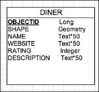
A dataset is modeled in a rectangular shape, with the name of the dataset in the header and
the attributes added beneath it, each with their own type as follows (note how the
OBJECTID
attribute is bold and underlined, which indicates a primary key):
The relationship is modeled as a line between the two datasets, and the primary keys are
highlighted in bold. Hence, if we model our current geodatabase, we should have
something similar to the following figure: