Environmental Engineering Reference
In-Depth Information
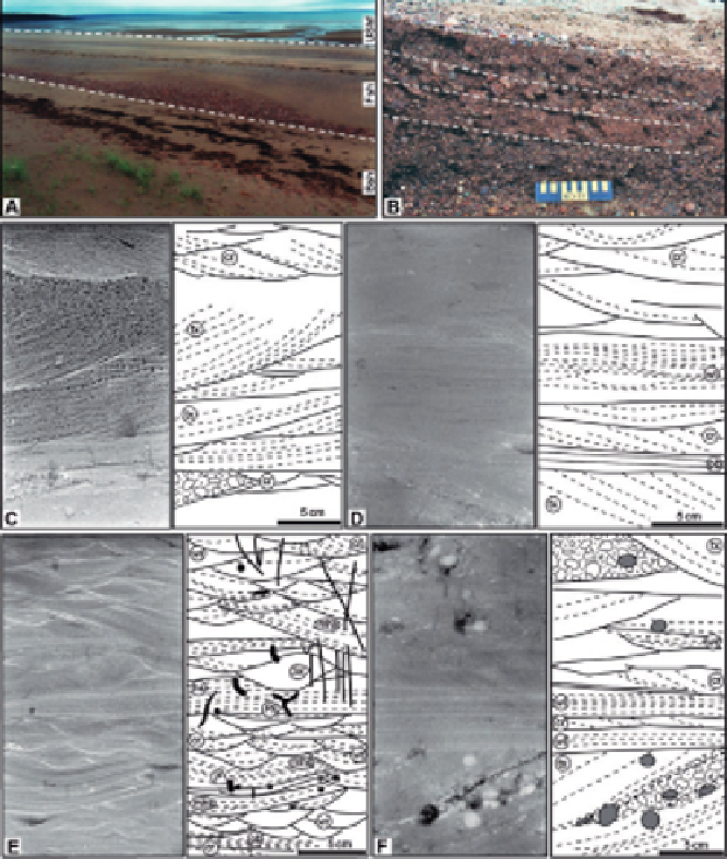
FIGURE 15
Photos, X-ray radiographs, and line interpretations of a modern tidally modulated
shoreface (TMS) from the Bay of Fundy, Canada.
Images from
Dashtgard et al. (2009)
,
and
Dashtgard et al. (in press)
. For all X-ray radiographs and line drawings, the landward direction
is to the left of the page and the oceanward is to the right. (A) Photo of a TMS taken during the
falling tide, showing the position of the backshore (Bsh), foreshore (Fsh), and upper shoreface
(UShf). The foreshore dips seaward at 2-4
and is 100-200 m wide. (B) Trench through beds of
pebbly sand and gravel that dip seaward (to the right). (C) Proximal upper shoreface: onshore-
directed trough cross-beds in sand, interbedded with ebb-oriented current ripples. (D) Distal upper
shoreface to proximal lower shoreface: trough cross-bedded and current-rippled sand with inter-
bedded wavy-parallel-laminated sand (possibly swaley cross-stratification). (E) Proximal lower
shoreface: complex vertical succession of wave ripples, current ripples, microhummocky cross-
stratification, plane beds, and hummocky cross-stratification. Sediment is muddy sand (lighter
colors indicative of higher mud content). Bioturbation is low (BI
¼
1-2) and is dominated by vertical
structures (e.g.,
Polykladichnus
,
Skolithos
). (F) Proximal lower shoreface: wavy-parallel laminae
and current ripples in sand, interbedded with trough cross-bedded pebbly sand. Acronyms used
for sedimentary structures: current ripples (cr), microhummocky cross-stratification (mhs), plane
beds (pb), trough cross-beds (tx), wave ripples (wr), and wavy-parallel laminae (wl). Acronyms used
for identifiable traces:
Planolites
(
P
),
Polykladichnus
(
Pk
), and
Skolithos
(
Sk
).
Search WWH ::

Custom Search