Environmental Engineering Reference
In-Depth Information
68
°
08
¢
24
²
W
Study area
36
°
24
¢
00
²
S
B
C
Algarrobo
del Águila
town
Floodplain
Channel
belt
10
143
C
C
C
200 m
A
D
5 cm
5 cm
E
F
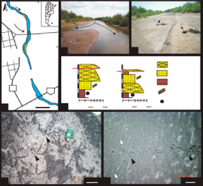
FIGURE 9
Sediments of channel-belt deposits of the Atuel river near Algarrobo del
´
guila town
(36
23
0
52.3
00
S, 67
08
0
25.9
00
W), La Pampa province, Argentina (A-D) and modern traces found
in its channel bed (E-H). (A) Location map showing the channel-belt deposits (blue), channel bars
(yellow) and study area. (B) and (C) View of the channel belt and emergent longitudinal bar under
current conditions (B) and during dry periods (C). Note also the location of shallow pits in figure
C. Channel-belt width is 28 m. (D) Measured sections on the bar top (log 1) and the channel floor
(log 2) in a dry period. (E) Bird tracks on a mud-draped channel floor (two arrowed). (F) Sand deposits
in channel bed showing eolian ripples (white arrows) and mammal trackway (black arrows).
theropod tracks might be less commonly preserved and recorded in this type of
outcrop. An additional example of contrasting preservation of groups of verte-
brate trace fossils in floodplain sediments is the Late Cretaceous ichnofauna of
Mongolia described by
Currie et al. (2003)
. The footprints are exclusively made
by large animals (mostly hadrosaurs, but also tyrannosaur theropods and titano-
saurs) that sunk more than 1 m into the mud of ephemeral lakes and swales of
meandering rivers (compaction was not considered). The absence of small foot-
prints and the preservation of delicate invertebrate trace fossils on bedding
planes was interpreted as an indication that the sediments may have been cov-
ered by enough water to prevent smaller animals from leaving their footprints
(
Currie et al., 2003
). A similar contrasting preservation of herbivorous (ornitho-
pod) and carnivorous (theropod) dinosaur tracks has been described for seasonal


Search WWH ::

Custom Search