Graphics Programs Reference
In-Depth Information
3.
In the top-right of your screen, click the Proposals drop-down list
and select Ex_7_3.
In this proposal, the model matches the end of Exercise 7.2 with
the industrial park building lowered to address visibility issues.
4.
Restore the Industrial Park bookmark.
5.
On the main toolbar, if the InfraWorks toolbar is not visible, click the
InfraWorks icon.
6.
If the Analyze toolbar is not visible, on the InfraWorks toolbar, click
the Analyze icon.
7.
On the Analyze toolbar, click Terrain Statistics.
8.
Pick points to outline a shape around the pond area, similar to the
dashed red outline shown in Figure 7.15. Double-click the last point
to complete the command.
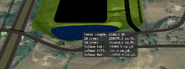
fIgure 7.15
Using the Terrain Statistics command to retrieve cut and fill
information about the pond
After completing the command, a panel should appear displaying
data about the area you've selected. The volume net should be around
-71,000 cu. yd. (-54,000 cu. m.), as shown in Figure 7.15. This value
can be used to help estimate the cost of constructing the pond.
9.
If the Terrain Themes panel is not visible, click Terrain Themes on
the Analyze toolbar.


Search WWH ::

Custom Search