Graphics Programs Reference
In-Depth Information
Figure 4.64 shows the Bonne (left) and the second Stabius-Werner (right) pseudo-
conical projections. The first was developed by R. Bonne and the second is one of three
pseudoconical designs by Johann Stabius and Johannes Werner.
Other Sphere Projections
Certain applications are best served by sphere projections that do not preserve any of
the properties above but instead are a compromise where no feature is greatly distorted.
The following are examples of such special projections. Perhaps the most original among
them cut (or interrupt) the continuous map into slices or gores.
Projections that were especially developed to portray the entire world on one map
often result in much distortion, mostly in regions located at the extremes of the projec-
tion. To improve the depiction of these distorted areas, “interrupted” forms splitting
the projection into gores have been developed. In this approach, many landmasses (or
oceans) can have their own central meridian, resulting in true shapes or conformality in
each region of the projected map.
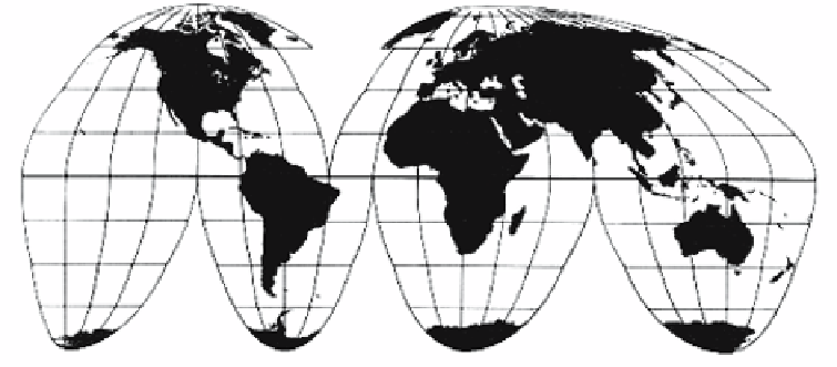
Goode's homolosine equal-area projection (Figure 4.65) is not a general sphere
projection. It was developed in 1923 by J. Paul Goode specifically to project the entire
Earth while trying to minimize the overall distortion of landmasses. Its main feature
is discontinuity. It “interrupts” the map (splitting it into slices called “gores”) in the
oceans, with the result that the gores distort the shapes of the oceans while showing
the continents in their true shapes. Mathematically, this projection is a combination of
the homolographic and sinusoidal projections, hence the name homolosine.
Figure 4.65: Goode's Homolosine Equal-Area Projection.
Gore is also:
1. A triangular point of land often found at road merges and diverges.
2. A triangular piece of cloth or metal used in three-dimensional fabrication.


Search WWH ::

Custom Search