Graphics Programs Reference
In-Depth Information
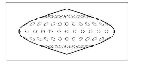
increases areas as we move away from the equator. (At the poles, the Tissot circles
would become infinitely large.)
(a)
(b)
Figure 4.45: Tissot Indicatrix for Sinusoidal and Mercator Projections.
A map prepared for determining the routes of new highways should be equidistant;
it should preserve distances. If the distance between two points on the sphere is
L
,then
the distance between them on the map should be
L/s
. In practice, an equidistant map
often shows true distances only from one point, the center of projection.
An azimuthal or zenithal projection preserves angles. Ideally, if the angle between
three points is
α
, then the angle between the same points on the map should be the same
α
. In practice, azimuthal maps maintain true angles only from one central point, and
even this property is achieved at the price of great distortions of areas and distances.
A map projection is conformal (also referred to as orthomorphic or equiangular)
when (1) all angles at any point are preserved, (2) lines of latitude and longitude intersect
at right angles, and (3) the shapes of small areas are preserved. Such a map corrupts
the size of large areas.
Table 4.46 lists the pairs of properties that can be combined in a single projection.
Projection
Area
Scale
Angle
Shape
Equal-area
—
no
yes
no
Equidistant
no
—
yes
no
Azimuthal
yes
yes
—
yes
Conformal
no
no
yes
—
Table 4.46: Properties That Can Be Combined.

Search WWH ::

Custom Search