Agriculture Reference
In-Depth Information
1
2
3
4
5
6
7
8
9
10
11
12
13
14
15
16
17
18
19
20
21
22
23
24
25
26
27
28
29
30
31
32
33
34
35
36
37
38
39
40
41
42
43
44
45
46
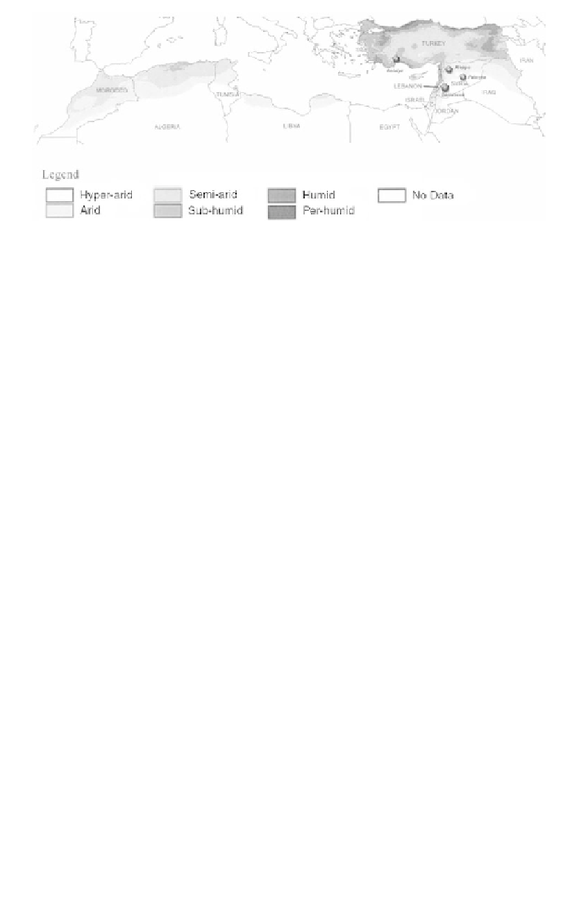
Fig
ure 16.1
Aridity in North Africa and West Asia.
[209
Because of the high degree of aridity in large parts of the region, agri-
cu
lture in the Near East is particularly vulnerable to drought. Most of the
ag
ricultural systems depend on rainfall. Irrigation water is scarce, and al-
th
ough the area under irrigation is expanding, supply constraints are likely
to
increase. The reasons are limitations on the total size of the extractable
w
ater resources, consideration of environmental and socioeconomic im-
pa
cts of large dam-building programs, continued population growth cou-
pl
ed with increasing urbanization, and competition among communities,
in
dustrial and service sectors, and agriculture for increasingly limited wa-
te
r resources. Irrigated agriculture currently consumes an average of about
Line
——
4.9
——
Long
PgEn
[209
Ta
ble 16.1 Climatic moisture regimes in North Africa and West Asia
Moisture regime
% Hyper-
%
% Semi-
% Sub-
%
% Per-
Area (km
2
)
Country/region
arid
Arid
arid
humid
Humid
humid
Algeria
71.7
15.9
8.6
3.8
0.0
0.0
2,381,741
Egypt
91.5
8.5
0.0
0.0
0.0
0.0
997,739
Ga
za Strip
0.0
16.9
83.1
0.0
0.0
0.0
363
Iraq
11.6
69.9
17.3
1.2
0.0
0.0
435,052
Israel
2.6
55.3
34.7
7.4
0.0
0.0
20,700
Jordan
23.5
69.8
6.7
0.0
0.0
0.0
88,946
Lebanon
0.0
0.0
19.5
55.3
15.1
10.1
10,230
Libya
80.9
17.6
1.5
0.0
0.0
0.0
1,757,000
Morocco
0.0
41.8
55.5
2.7
0.0
0.0
458,730
Syria
0.0
71.3
23.1
3.3
1.4
0.9
185,180
Tunisia
14.4
52.3
30.3
3.0
0.0
0.0
164,150
Turkey
0.0
0.0
29.6
48.7
18.5
3.2
779,452
W
est Bank
0.0
20.4
74.4
5.2
0.0
0.0
5,900
% of total area
56.8
21.4
12.4
6.9
2.0
0.4
7,285,183
Source: Computed from the GIS data archived at the International Centre for Agricultural Research in Dry
Areas (ICARDA).


Search WWH ::

Custom Search