Environmental Engineering Reference
In-Depth Information
Metamodel performance
4
tree belt/hedgerow: 90
to contour;
5
woodland;
6
ungrazed improved grassland;
7
grassland with drains removed;
8
unimproved grassland/rough grazing;
9
marsh/wetland.
These units were chosen based on dominant land
use types currently within the catchment and
those management changes that were perceived
as likely to have an impact on flood peaks.
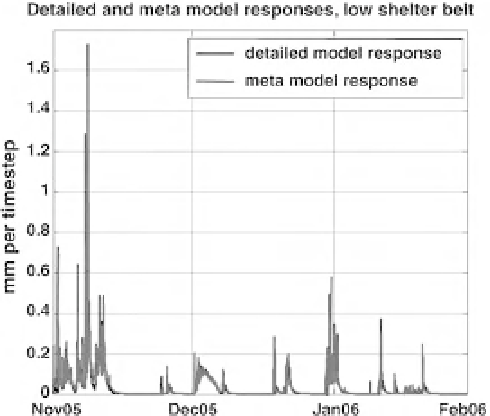
The ability of the metamodel to represent de-
tailed model response is illustrated in Figure 3.9
for a grazed hillslope with a woodland buffer strip
at the base of the slope (category 2 above).
Those metamodels that are conditioned on
physics-based models (namely: grazed improved
grassland, ungrazed improved grassland, improved
grassland with no drains and three tree-belt inter-
ventions) are by implication conditioned on
small-scale data. Uncertainty is handled through
generating multiple samples of physics-based
model responses to account for uncertainty on
the data. Each individual detailed model simu-
lation is then passed to the metamodel and a
corresponding response generated through auto-
matic calibration of the metamodel to this re-
sponse, using Monte Carlo simulation and a
least squares fit measure. This allows a set of
behavioural samples to be propagated forward
The aim of the metamodel is to provide a compu-
tationally efficient model that is able to capture
the response of the detailed physics-based model;
ideally the model would retain some physical
interpretability through the use of an appropriate
conceptual structure. A common simple represen-
tation of the rainfall-runoff process is to consider
a loss function, representing soil water controls
on evaporation, and routing, typically represent-
ing fast and slow response pathways - the Imperial
College Rainfall-Runoff Modelling Toolbox
(RRMT; Wagener et al. 2004) has a large library
of alternative structures. A suitable model struc-
ture was defined (Fig. 3.8).
The metamodelling strategy requires that
eachfield in the Pontbren catchment is classified
into a land use/management type, so that the
corresponding set of field-scale models can be
applied. The field types currently included are:
1
grazed improved grassland;
2
tree belt/hedgerow: near bottom of slope;
3
tree belt/hedgerow: near top of slope;
Overland flow
cm
ax
rtl
r
1
=
α
1
R
rtg
(1 -
α
1
)
R
rts
NWF
Q
Fig. 3.8
Metamodel structure and associated
parameters.
Fig. 3.9
Metamodel performance.