Environmental Engineering Reference
In-Depth Information
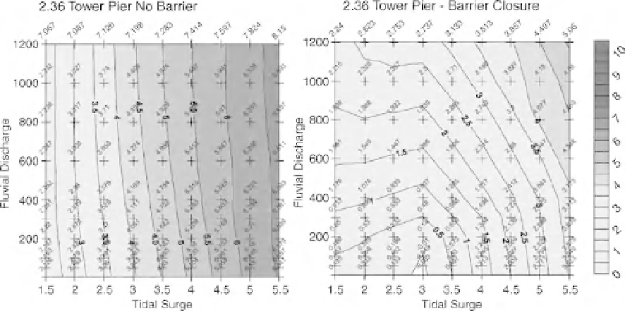
Fig. 23.4
Example structure function for Tower Pier (ISIS model node 2.36). (See the colour version of the figure in
Colour Plate section.)
allowed for a 20% increase in Thames fluvial flow
in 2052 and 2102 (the 20% increase was the cur-
rent government advice from Defra, 2006).
rise vertically to levels higher than any simulated
water levels).
.
Wind-generated wave effects were not required
to be predicted - in the outer Estuary these can be
significant and can be added as a post-process to
the generated 'still water' levels.
.
The operation rules for the Thames Barrier,
Richmond weir and Teddington weir could be
idealized and included in the models in a consis-
tent fashion.
Appropriateness of 1D modelling
The 1D in-bank model was selected as being most
appropriate for this project due to a number of
reasons including:
.
Themodel was already in existence andhad been
calibrated to adequately represent
in-channel
water levels.
.
The method of generating the structure func-
tions required two sets eachof 81 simulations to be
undertaken for each climate scenario; the model-
ling approach had to be fast enough to ensure
that some 500 simulations could be undertaken
within a reasonable period of time. As the 1D
model can simulate a few days' tides in less than
1 minute this criterion could be achieved.
.
Modelling of the floodplain was not required as
the project objective was to determine extreme
water levels without flooding. The 'glass-walled'
1D model is a very suitable method to achieve
these results (in a 'glass-walled' model both ex-
tremes of the simulated channel cross-section
Flood Mapping
Background
The Environment Agency's Flood Map (www
.environment-agency.gov.uk) is a set of maps
aimed primarily at increasing awareness of flood
risk. Flood Zone data form the base layers for the
Flood Map and are used to provide information
for planning consultation compliant with UK gov-
ernment planning policy statement PPS25 (which
defines the process used in England to avoid inap-
propriate development in areas at risk of flooding).
Flood Zones are geographical areas defined by