Environmental Engineering Reference
In-Depth Information
The impact has been greatest in the Northwest of
the basin and, as this subregion has changed from
beingsemi-aridtosemi-humid, groundwater levels
have risen by up to 7m and land use has changed
from predominantly pasture to arable.
Problems associated with flooding in the basin
first began to attract attention at the beginning
of the 20th century, leading to several studies
(CFI 1980; AEE 1990) of varying scope and
geographical extent. It is important to point out
that during this period (prior to implementation of
artificially engineered drainage works), theNorth-
west Region (Region A) and the Western lake
system (Region C) constituted separate drainage
systems that did not connect or interact with the
natural fluvial systemof the R´o Salado (Region B).
In 1997, the provincial government commissioned
development of an IntegratedMaster Plan (IMP) to
identify possible long-term, basin-wide solutions
to flooding and waterlogging problems and, in
turn, create more favourable conditions for farm-
ing investment and development in the catch-
ment. While the primary aim was to enable
farmers to increase their productivity, it was rec-
ognized that this plan must be realized within a
framework of sustainable management and con-
servation of environmental capital. The IMP was
funded by the World Bank, and the results were
presented to the provincial government inDecem-
ber 1999 (Halcrow Group 1999).
Development of the IMPwas the first attempt at
an integrated approach to managing flooding pro-
blems at a regional scale in Argentina, comprising
studies across all of the relevant disciplines, from
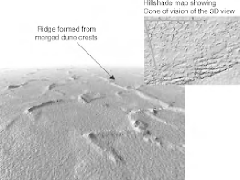
Fig. 22.2
Three-dimensional view of aeolian features in
the Northwest of the Buenos Aires Province (red box in
Fig. 22.1b). (See the colour versionof this figure inColour
Plate section.)
average annual floods within banks. In fact, the
basin is so poorly drained by its surface water
channel system that the mean flow of the R´o
Salado close to where it discharges to the ocean
is only 73m
3
/s, while its maximum historic flow
was measured in 1985 at just 446m
3
/s, both dis-
charges being far below what would be expected
for a catchment of this size. The reason these
discharges are so small is that excess precipitation
is stored through long-term, catchment-wide
flooding (Fig. 22.3).
The extent and duration of flooding in the basin
has increased during the last four decades, due to
increasedprecipitationthat isprobablypartofawet
cycle associated with natural climatic variability.
Fig. 22.3
(a) Satellite image showing flooding in the Northwest of Buenos Aires Province (Region A) - see flooding
captured behind the dune crests shown in Fig. 22.2. (b) Flooding in the R´o Salado (Region B). (See the colour version of
this figure in Colour Plate section.)