Environmental Engineering Reference
In-Depth Information
freely available datamay be used to extract surface
water elevations and estimate a reliable surface
water slope, provided that the river reach is long
enough. Kiel et al. (2006) assessed the performance
of X-band and C-band SRTM DEMs for the Ama-
zon River and a smaller river in Ohio. They con-
cluded that the C-band SRTMDEM gives reliable
water elevations for smaller river reach lengths as
well. They also state that while SRTM data are
viable for hydrological application, limitations
such as the along-track antennae offset and the
wide look-angle suggest the necessity of a new
satellite mission (SWOT - Surface Water Ocean
Topography; http://decadal.gsfc.nasa.gov/swot.
html) for improved water elevation acquisition.
For changes inwater stage retrieval with InSAR
technology, the specular reflectionof smoothopen
water causes most of the return signal to be re-
flected away from the antenna, rendering interfer-
ometric retrieval difficult if not impossible.
However, for emerging vegetation in inundated
floodplains, Alsdorf et al. (2000, 2001, and also
2007 for a short review) show that it is possible to
obtain reliable interferometric phase signatures of
water stage changes (at centimetre scale) in the
Amazon floodplain from the double bounced
return signal of the repeat-pass L-HH-band Shuttle
Imaging Radar (SIR-C). L-band penetrates the veg-
etation canopy and follows a double bounce path
that includes the water and tree trunk surfaces,
is unable to extract flooding from urban areas,
which for obvious reasons would be desirable
when using remote sensing for floodmanagement.
Note that recently launched SAR satellites with
higher spatial resolution (1-3m) and carefully
chosen incidence angle and wavelength (e.g.
TerraSAR-X; Fig. 11.4) may allow reliable flood
extraction from urban areas after careful subtrac-
tion of radar shadow and layover modelling from
LIDAR (Mason et al. 2010).
Generally, the magnitude of the deteriorating
effects, which determines the choice of an ade-
quate processing technique, is a function of spatial
resolution, wavelength, radar look angle and
polarization. Henry et al. (2006) compared different
polarizations for flood mapping purposes and con-
cluded that HH (horizontal transmit-horizontal
receive) is most efficient in distinguishing flooded
areas.
Water stage retrieval
Direct measurements
Space-borne image-based
direct
measurements
have only been obtained from the Shuttle Radar
Topography Mission (SRTM) flown in February
2000 (Alsdorf et al. 2007). Despite the degraded
vertical accuracies over inland water surfaces (up
to
18.8m) of SRTM DEMs, LeFavour and
Alsdorf (2005) showed that these globally and
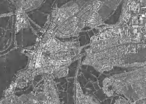
Fig. 11.4
A 3-m-resolution TerraSAR-X image
of flooding in Tewkesbury, UK, in July 2007
(dark regions are water and radar shadow areas).
DLR (2007).