Environmental Engineering Reference
In-Depth Information
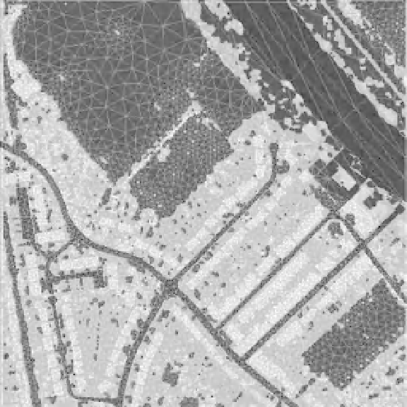
Fig. 11.3
Mesh constructed over vegetated
urban area (red
¼
mesh, blue
¼
building/taller
vegetation heights; a river is present in the
northeast corner). After Mason et al. (2007a).
(See the colour version of this figure in Colour
Plate section.)
cells. If LIDARdata are averaged to representDTM
heights on a lower-resolution model grid (e.g. 1-m
LIDAR data averaged to a 10-m model grid), care
must be taken not to smooth out important topo-
graphic features of high spatial frequency such as
embankments. Map data can be used to identify
the embankments so that this detail can be
preserved in the DTM (Bates et al. 2006).
In urban flood modelling studies using lower-
resolution models where a grid cell may occupy
several buildings, different approaches to the
calculation of effective friction on the cell have
been developed, based on object classification
from LIDAR or map data. The first approach sim-
ply masks out cells that are more than 50% occu-
pied by buildings, treating the edges of the masked
cells as zero flux boundaries. The second uses
a porosity approach, where the porosity of a cell
is equal to the proportion unoccupied by buildings
and therefore available for flow (Bates 2000;
Defina 2000). Friction in the porous portion of the
cell may then be assigned locally or globally.
The effect of errors in LIDAR DTMs on
inundation predictions in urban areas has been
considered in Neelz and Pender (2006) and Hunter
et al. (2008). These studies concluded that
uncertainty in friction parameterization is a more
dominant factor than LIDAR topography error for
typical problems. This is considered inmore detail
in the following chapter.
Use of Remotely Sensed Flood Extent and
Water Stage Measurements for Model
Calibration, Validation and Assimilation
Early launches of satellites and the availability of
aerial photography allowed investigation of the
potential to support flood monitoring from space.
There have been notable studies on integrating
data from these instruments with flood modelling
since the late 1990s. A more recent consensus
among space agencies to strengthen the support
that satellites can offer has stimulated more
research in this area, and significant progress has
been achieved in recent years in fostering our
understanding of the ways in which remote sens-
ing can support or even advance flood modelling.