Geography Reference
In-Depth Information
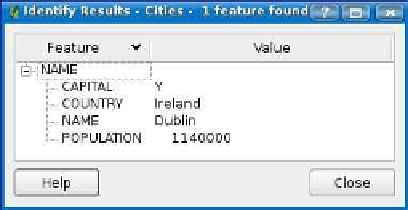
Figure 3.17: QGIS Identify results
Selecting Features
Selecting features is another common operation when working with
attributes. A selection set is used for a number of operations, as we'll
see shortly. Here we'll illustrate a simple usage—zooming to the extent
of the selection set.
In QGIS there are two ways to select a feature. The first is using the
Select Features
tool, located next to the
Identify
button. Click the tool,
activate the layer, and then drag a rectangle on the map around the
feature(s) you want to select. When you release the mouse button, the
features contained in the rectangle will be selected and drawn in a high-
lighted color (the color is customizable from the Options dialog box).
The other way to select features is to use the attribute table selection
Once you have a selection set, you can zoom to it by using the
Zoom to
Selection
tool or by using the menu option found in the
View
menu.
Using the Attribute Table
By now it's clear that GIS layers have attributes associated with the
features.
7
The attribute table not only gives us a view into the data
behind the features but in a typical application allows us to edit, select,
and search.
In QGIS, as in all desktop GIS applications, you can view the attribute
table for a layer. The attribute table for the
cities
layer is shown in
Usually this is true—you could have a layer with no attributes.
7.


Search WWH ::

Custom Search