Geography Reference
In-Depth Information
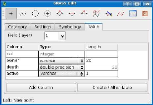
Figure 12.5: Adding columns to the new GRASS map table
We quickly realize in using our shiny new
water_wells
map that it is
lacking something. We should have had a
name
field to store the name
of the well. For residential wells, this probably isn't important, but it's
likely that the managers of Quantum GIS City will want names on their
wells to more easily manage them. No problem—we can easily add the
new column and fix any existing wells so they have a name.
To add a
name
column, begin editing the
water_wells
map, and click the
Table tab. We now see the table with its current columns and their
types. To add a new column, just click the Add Column button, and fill
in the details.
What about the well(s) we already created? The GRASS edit tools allow
you to edit the attributes for any feature. To edit the attributes for an
existing feature, click the
Edit attributes
tool. This brings up the same
dialog box you see when entering the attributes for a newly created
feature. Now there is a blank
name
field. We just fill it in with the name
the Update button. You'll have to repeat this for all the existing wells.
Of course, this illustrates the point that you should think about your
requirements before creating the data. It will save you time and energy,
especially if you realize it too far into your project.


Search WWH ::

Custom Search