Geoscience Reference
In-Depth Information
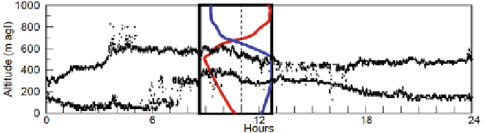
Fig. 4.10
Time series of cloud base (estimated from ceilometer) and cloud top (estimated from
cloud radar), December 9, 2003. The
rectangle
in the middle of the figure corresponds to the
profiles measured with a radiosounding at 11 UTC (
dashed line
):
red line
=
temperature with a
horizontal scale of 10 K, and
blue line
=
humidity with a horizontal scale of 100%. (Fig. 6 from
Ruffieux et al.
2006
)
under which the light fleck is seen and then computes the cloud base height from
simple trigonometric formulas.
Today, following the increasing pressure to automate observations, mono-static
methods are used which are based on the measurement of time delay. This is
the original field of operation for ceilometers, which nowadays are also used for
determining aerosol profiles in the boundary layer (see below).
Fog and low cloud top and base heights may be derived from 78 GHz frequency-
modulated continuous wave (FMCW) cloud RADAR and laser ceilometer measure-
ments. The base layer is well measured with a ceilometer while the top of the cloud
is determined using the 78 GHz FMCW RADAR. This method for cloud top deter-
mination is based on determining the height at which the RADAR signal falls below
a defined threshold level. This W-band RADAR is most sensitive to drizzle size
drops, so it is not sensitive to clouds with only very small drops. Thus, in thin
mist the cloud RADAR may not provide an indication of the fog top. The rapid
decrease of the RADAR sensitivity below 120 m above ground level is another lim-
itation in the measurement of low fog layers (Ruffieux et al.
2006
). Figure
4.10
shows an example for a simultaneous cloud top detection by a cloud RADAR and
cloud base detection by a ceilometer, and validates the results by a comparison to
radiosonde measurements. There was fog at night of this winter day, as the cloud
base was nearly at the ground before 6 a.m. Generally, cross sections through non-
precipitating clouds can be obtained from Ka- and W-band RADARs, which operate
at wavelengths of a few millimetres (see also
Table 3.2
).
4.3 Vertical Profiles of Atmospheric Variables
So far, we have dealt with the general vertical structure of the ABL and the demar-
cation of several sublayers of the ABL. For many purposes, detailed profiles of
certain atmospheric variables such as wind speed, temperature, or humidity must be
known throughout the ABL with reasonable accuracy and high vertical resolution
(see Table
4.2
).
Search WWH ::

Custom Search