Environmental Engineering Reference
In-Depth Information
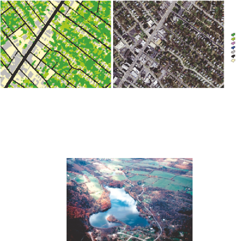
Baltimore city
land cover
Tree canopy
Grass/shrub
Bare earth
Water
Buildings
Roads
Other paved
surfaces
FIGURE 10.2
Differentiation of the elements of heterogeneity within patches, illustrated by coarse land cover
types (left) present in human settlements. In this urban example, which is based on the aerial photograph on the
right, the elements of terrestrial patchiness are dominant kinds of vegetation, including grass or woody, surfaces
including bare or paved, and buildings. Water is also mapped. Patches can be discriminated either by computer
algorithm or manually based on the clustering of the different kinds of elements in space, and the abruptness of
shifts in distribution of the three kinds of elements. Principles of urban patch classification are described in
Cadenasso et al. (2007)
.
(Image copyright M.L. Cadenasso and K. Schwarz, and used by permission.)
FIGURE 10.3
A landscape ecology perspective on ecosystem heterogeneity. This landscape in Dutchess
County, New York, combines terrestrial and aquatic patches; wild, cultivated, and built patches; and a transporta-
tion network. The landscape ecology perspective invites ecologists interested in populations, communities, and
ecosystems to understand how patch composition, patch structure, patch adjacency, and the fluxes among
patches, both above and below the surface, determine landscape and ecosystem function.
(Image copyright S.T.A.
Pickett, and used by permission.)
that takes heterogeneity as its core concern (
Forman and Godron 1986
). Landscape ecology
takes a spatially extensive perspective, based on the technologies of aerial photography
and remote sensing and on the accumulation of spatially distributed ecological samples
(
Figure 10.3
). As the analytical tool of geographic information systems (GISs) has become