Database Reference
In-Depth Information
is much more tightly coupled with data, compared with that of the FGDC
metadata standard. Such a coupling is an important aspect in metadata-driven
data integration.
45
Another extensive data description framework for Earth
science initiatives is the Semantic Web for Earth and Environmental Termi-
nology (SWEET) developed by NASA.
46
SWEET is a standard vocabulary
rather than a full-fledged metadata framework, and it includes a variety of
data description components in the context of physical phenomena; processes;
and properties, sensors, space, time, and units.
10.2.4 Approaches to Integrating Geospatial Data
Traditional data integration basically follows a schema-matching approach in
which related schema components (relations and attributes) from the differ-
ent sources are identified, homogenized, and suitably integrated to provide the
user with a single conceptual view over the data managed at the sources.
6
-
9
Using such a view, the distributed data then can either be physically inte-
grated at a single site or queried in a uniform and transparent fashion. The
former approach then leads to some kind of data warehouse that physically
stores the integrated data, but now in a homogeneous representation and for-
mat, leading to the
physical integration
of data. The latter approach, on the
other hand, results in a federated or multidatabase system, realizing a so-
called
logical integration
. Key to the integration is resolving the various types
of structural and semantic heterogeneities that occur due to differences in
data representation and meaning.
47
For integrating geospatial data sources, the approach can be significantly
more complicated, especially because there is a wider variety of geospatial data
types (compared to just relational data), including various vector data repre-
sentations and formats for field-based data, as discussed above. But, what is
actually meant by
integrating geospatial data
? In practice, the most common
view of this is to have a GIS that allows users to overlay different
themes
(or
layers
). That is, for a given geographic area, there are several georeferenced
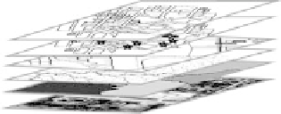
themes that represent different characteristics of that area. Figure 10.2 illus-
trates an example in which several themes based on vector and field-based data
Field-based layers
Vector data layers
Figure 10.2
(See color insert following page 224.) Illustration of an overlay
of themes in a GIS. Geo-referenced and aligned layers include both vector
data and field-based data.