Geoscience Reference
In-Depth Information
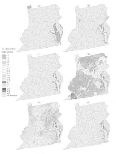
Plate 13.1
(See color insert following page 114.) Fuzzy accuracy maps of (a) water, (b) developed, (c) barren,
(d) forested upland, (e) herbaceous planted/cultivated, and (f) wetlands.
planted/cultivated tended to be more accurate in populated areas. On the other hand, developed
areas around Richmond and Roanoke had lower accuracy levels compared with other urbanized
areas, such as Baltimore, Washington, DC, Philadelphia, and Pittsburgh.
For the forested upland accuracy map, some areas had abnormally low accuracy levels, such
as those in central and southern Pennsylvania. The southwestern corner of Virginia had a very low
level of accuracy (agreement level 6), indicating that there was almost no match at all between
sampled pixels and mapped pixels in this area. This raised questions about both the thematic map
classification process and the quality of the reference data. Thus, the fuzzy accuracy maps indicated
irregularities or accumulated errors associated with both the thematic map and reference data set.
This information is not illustrated using conventional accuracy measure; however, it is very bene-
ficial for designing sampling schemes to support reference data cross-examination.
Table 13.3 presents the fuzzy cover-type-conversion
rule set that is, as mentioned above,
somewhat similar to a combination of four error matrices in one. The possibilities derived from
each fuzzy rule should be interpreted relatively. For example, for a low accuracy, barren-dominant
area, the possibility for a barren-labeled pixel to be forested upland (i.e., rule 3-a) was the highest
compared with other cover types, including barren, and it was double the second highest possibility
of barren-to-herbaceous planted/cultivated (i.e., 0.47 vs. 0.24). Note that the outcomes of each
fuzzy rule were not normalized (i.e., to have the highest possibility equal 1) for the purpose of
global rule-to-rule comparison. For instance, the wetlands-to-forested upland possibility of a wet-
lands-labeled pixel in a low-accuracy, wetlands-dominant area (rule 6-a) was double (0.69 vs. 0.33)
the developed-to-forested upland possibility of a developed-labeled pixel in a low-accuracy, devel-
oped-dominant area (rule 2-a). Unlike an error matrix, the fuzzy rule set table provided significant
insights into spatial accuracy variation of the thematic map under study. As the size of the referenced
data set was relatively small compared with the area it covered, we used only two arguments
(inputs): the accuracy levels and cover type dominance. If there are more sampled data in future
analyses, additional arguments (factors) that might affect the classification process (e.g., slope,
altitude, sun angle, and fragmentation) can be included in the fuzzy rules, and potentially more
insights into the thematic map spatial accuracy patterns can be revealed.