Geography Reference
In-Depth Information
Border and neat line:
Maps are commonly contained within a
border
that assumes a
conventional geometric shape, usually a rectangle. The purpose is largely aesthetic, though in
topics and articles borders serve the practical function of clearly differentiating map and text.
Typically, borders are bold lines. Often they frame a thinner
neat line
whose purpose is purely
aesthetic.
Taking It to Scale
Scale
is the relationship between a distance as measured on a map and the corresponding actu-
al distance on Earth's surface. Calculating distance between locations and comparing the size
of areas are two of the more important functions of maps.
Going the distance
The scale of a map may be stated in three rather different ways, described in the following sections.
Figure 5-1 shows you what the three ways look like. Some maps include just one of them. Others in-
clude two, and still others all three. Perhaps the most important thing to remember is that every map
has a single scale, but a cartographer has three ways to tell you what it is. If, therefore, a single map
contains two or three of the scale-types, then each is saying the same thing, albeit in a different way.
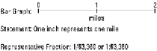
Figure 5-1:
Three ways to in-
dicate the scale
of a map.
Bar graph
A
bar graph
looks like a miniature ruler. But, whereas the ruler you use may show inches and milli-
meters, theoneonthemapshowsmiles andkilometers, (asshowninFigure5-1).Theprincipal virtue
of the bar graph is that it provides a clear visual reference to the size of the area portrayed on the map.
For actual measurement, however, it may be a bit unwieldy because you can't pick it up like you can
a real ruler.