Geography Reference
In-Depth Information
topic of maps had Mercator's publisher decided to put something else on the cover. Who
knows? Maybe I'd be advising you to go out and buy a really nice aardvark.
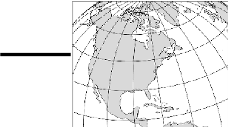
The Robinson projection
Dr. Arthur H. Robinson, a noted American cartographer, introduced this cylindrical projection in
1963 (see Figure 4-2). If you lie really well, people may not notice. In fact, they may love you be-
cause of it. With all due respect and admiration to the good doctor, his map lies really well!
Although the projection contains distortion with respect to size and shape of land areas as well as to
distance and direction, it has good overall balance with respect to these elements. In particular, the
high latitude land areas are much less distorted than in the Mercator projection. Furthermore, Robin-
son's format does not have the interruptions of Goode's map. As a result of these pluses, in 1988 the
National Geographic Society adopted the Robinson projection for its world maps. Partly because of
the prestige and publicity of that designation, the Robinson projection has become one of the popular
choices among publishers of atlases and classroom wall maps.
The Lambert Conformal Conic projection
Johann Heinrich Lambert (1728-1777), a noted German physicist and mathematician, developed the
Lambert Conformal Conic projection in 1772 (see Figure 4-7). Projections cannot correctly show the
shapes of large areas, but they can be drafted such that the shapes of small areas closely
conform
to
reality. That is what the Lambert Conformal Conic Projection achieves.
Figure 4-7:
Lam-
bert Conformal
Conic projection.
Accuracy of shape (conformality) is most closely achieved where the cone, which is intrinsic to a
conic projection, touches the globe. If you refer back to Figure 4-4, you can see that the conic pro-