Geography Reference
In-Depth Information
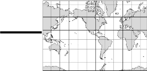
The Mercator projection
GerhardKremer,who'smuchbetterknownbyhisadoptedLatinname,GerardusMercator,developed
theMercator projection in1569.Thiscylindrical projection (seeFigure4-5)iseasily themostfamous
world map of all time. Mercator crafted his projection to aid navigation, and in that regard, the map
is a gem. Straight lines on this map correspond to true compass bearings so a navigator could use it
to plot an accurate course. This achievement was a very big deal in the late 16th century, and by the
middle of the 17th century, a majority of Western European navigators swore by this map.
Figure 4-5:
The
Mercator projec-
tion.
Because of its seafaring fame, the Mercator Projection later came into widespread use as a general-
purpose map. That is, it found its way into classrooms as wall maps and into topics and atlases. It
became more or less
the
official world map, which is unfortunate because, although the shapes of
landmasses are fairly accurate, the projection is extremely distorted with respect to size.
Notice that the lines of longitude on the Mercator projection don't meet at the Poles, as is the case in
reality. Instead, the map shows the lines of longitude as parallel lines. This means that the North and
South Polar regions have been stretched and become lines (the top and bottom borders of the map)
that are as long as the Equator — 25,000 miles. One result is that land areas become disproportion-
ately enlarged the closer they are to the areas of maximum distortion — the Poles. Alaska and Green-
land are good examples. Alaska appears much larger than Mexico, while Greenland appears much
larger than the Arabian Peninsula. In reality, Mexico is larger than Alaska, and the Arabian Peninsula
is bigger than Greenland, but you'd never know by looking at the Mercator projection.
Because of distortions like these, the Mercator projection has fallen out of favor as a general-purpose
map. No single map has replaced it. Instead, makers of wall maps and atlases have been using a num-
ber of other projections (some of which are mentioned below) that give a truer view of the relative
sizes of Earth's feature.