Geography Reference
In-Depth Information
A = Latitude 20° North, Longitude 10° West
B = Latitude 5° South, Longitude 20° East
C = Latitude 22° South, Longitude 17° West
Geo-jokes
Q. Why did the chicken cross the equator? A. To get to the other hemisphere.
Q. Why was longitude boiling mad? A. Because it had 360 degrees.
Q. Why weren't there any parallels on the map? A. Because the cartographer had no lat-
itude in the map's design.
Q. Why were the meridians lost? A. Because they were in a parallel universe.
Had enough? I certainly have. But if this is your idea of humor, you can get more of it on
the About.com geography page (
http://geography.about.com
)
.
Minutes and seconds that don't tick away
On Earth's surface, adjacent lines of latitude and longitude may be several miles apart, and that cre-
ates a potential problem if you wish to state the absolute location of a spot that is “between the lines.”
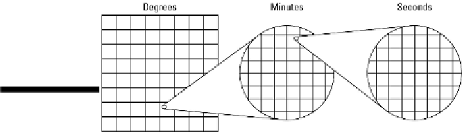
For this reason, the graticule contains a couple of levels of refinement (see Figure 3-4).
Figure
3-4:
Degrees,
minutes,
and
seconds.
First, the space between successive degree lines may be subdivided into 60 equidistant units called
minutes
('). Second, the space between successive minute lines may be subdivided into 60 equidistant
units called
seconds
(“). And if more exactitude is needed, then seconds may be carried out to as
many decimal points as may be necessary. I'll show you an example in just a second, but that reminds
me to make a point.