Geography Reference
In-Depth Information
Graticule
As far as geographers are concerned, latitude and longitude make for a very special grid that
deserves a special name,
the graticule,
to distinguish it from every other kind of grid. Indeed,
this name is so special that many dictionaries and computer spell-check programs do not re-
cognize it. But geographers do, and they are extremely impressed if they hear it used by a
layperson.
But more important than saying “graticule” is the ability to use it properly. That means, among other
things, correctly identifying the grid coordinates (latitude and longitude) of locations indicated on a
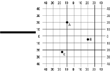
map. With that in mind, take a look at Figure 3-3, which represents a portion of the graticule. Note
that lines of longitude are shown parallel (when in reality they converge toward the poles) and that
only every tenth degree line of latitude and longitude are indicated. World maps typically “skip” lines
in a similar fashion, lest they become cluttered by the graticule. But what I really want you to focus
on are the three dots lettered A, B, and C. See if you correctly can identify the coordinates of each
dot, keeping in mind the following rules:
1 .When reporting coordinate locations, always give the latitude first, and then give the longitude.
(Why? I have no idea, and I don't think anybody else does either. It's just the rule.)
2. Correct reference to latitude must specify whether a location is north or south of the equator
(Latitude 0°), assuming the location is not on the equator itself.
3. Correct reference to longitude must specify whether a location is east or west of the Prime
Meridian (Longitude 0°).
Figure 3-3:
A
represent-ation
of a portion of the
Earth's grid.
The correct locations of the dots are as follows: