Geography Reference
In-Depth Information
and what not to. In the end, I decided to focus on two topics, international borders and voting
district boundaries, which I believe are particularly timely.
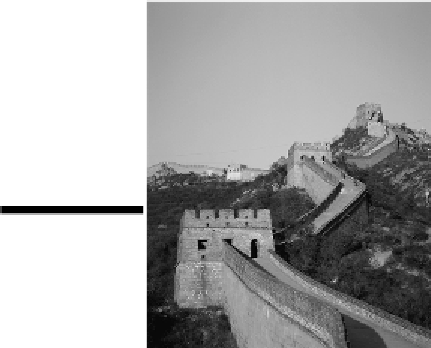
Figure 14-1:
The
Great Wall of Ch-
ina is an endur-
ing symbol of the
human fondness
for dividing and
controlling
the
Earth.
Drawing
and
Re-Drawing
the
Boundaries
of
the
World
Many years ago I attended a lecture concerning “lost nations.” I had no idea what it was going to be
about. I figured maybe the entire populations of several countries had gotten off at the wrong exit,
refused to ask for directions, and were, you know, lost. Or maybe they were all stuck on a subway
someplace, like that old folk song about the man who never returned. I was wrong. The presenter had
prepared a geographical analysis of all the countries of the world that had ceased to exist since 1850.
Dozens and dozens of those countries had been “lost” to the family of nations. Maps of the world's
countries are quite common. But neither the nations nor the boundaries between them are etched in
stone. Since that lecture, the Soviet Union, East Germany, Czechoslovakia, and maybe one or two
other countries have joined the “lost” list. But the world is hardly running out of nations. Indeed,
new countries seem to be springing up faster than existing ones are disappearing. The Soviet Union
fractured into 15 nations and Yugoslavia into 5. Czechoslovakia split into the Czech Republic and
Slovakia. In Africa, Eritrea broke away from Ethiopia.
Meanwhile, a host of new candidates are vying for countryhood. People in Chechnya want to be free
of Russia. The Tamils want to be separate from Sri Lanka. Basques in Spain and France want a coun-
try of their own. And on it goes. If past is prologue, then I have no doubt that a comparison of today's
world map with future ones will reveal a mix of new nations and lost ones.