Geography Reference
In-Depth Information
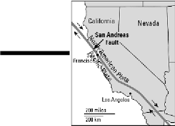
Figure 6-7:
The
San
Andreas
Fault.
Actually, and as has been seen, “sudden fits and starts” is more accurate than “slowly moving.” Pres-
sure slowly builds on both sides of the fault line. Every so many years, enough pressure accumulates
to overcome the friction of resistance offered by gazillions of tons of crust. At that point, parts of
California slide by each other — not as continuous slow movement, but rather in short and sudden
spurts as earthquakes occur. As a result, California is slowly being torn apart.
People at risk
Ultimately, geography investigates natural phenomena to gain information that is relevant to
humans. Earthquakes are particularly significant because of their destructive potential and be-
cause so many earthquake-prone areas are densely populated. More important, therefore, than
long-term scenarios such as the splitting of California are short-term consequences for Los
Angeles, San Francisco, and several other major cities that are on or near a fault line. And
California isn't the only place affected. Examination of Figure 6-4 reveals several other loc-
ations where plate boundaries coincide with major metropolitan areas. That includes about a
dozen or so major cities along the West Coast of the Americas from Mexico City to Santiago,
Chile. The same applies to virtually all of Japan and many parts of Southeast Asia. Then con-
sider the long interface between the Eurasian Plate and its southern “neighbors” that extends
from the Himalayas westward through Italy. All told, more than two billion people live close
enough to an active fault zone to be in harm's way.
How earthquakes kill and maim
Collapsing buildings are the cause of most earthquake-related casualties. That is, most people who
end up as statistics are either inside or next to a building that experiences structural failure. The walls