Geology Reference
In-Depth Information
observe the Upper Cretaceous bituminous shales,
i.e., a
the lagoon (Fig.
4
a).
Geosite A2
is located at the northern
limit of the lagoon, next to an artesian well that delivers hot
sulphur-laden water from a deep groundwater residing in
Cretaceous rocks. This geosite also offers a geological
landscape that shows the thick white Miocene marls beneath
the slab of Moghrebian calcarenites (Fig.
4
b). The lagoon
corresponds to an area of thin and easily eroded Moghrebian
calcarenites between two NNE-trending, thick Moghrebian
deposits (shallow marine to sub-aerial dunes). These two
geosites would need adequate interpretative panels that
inform geotourists of the origin of the splendid Dakhla
lagoon and of the related environmental problems.
Geosites A3 and A4
are located south of the Dakhla
lagoon and illustrate the stratigraphy of the Tarfaya-Bouj-
dour basin.
Geosite A3
is located at Portorico beach, about
60 km south of the crossroad at the entrance of the Dakhla
peninsula. Its major interest is the outcrops of Eocene for-
mations beneath Miocene deposits (Fig.
5
a, b). A fossilif-
erous bed (containing whale bones and shark teeth; Fig.
5
e)
close to the base of the Eocene cliff is presently exploited by
commercial fossil dealers and amateur fossil collectors,
without permission, and clearly deserves protection. The
sedimentary layers display remarkable dewatering structures
(Fig.
5
c) and neptunian dykes (Fig.
5
d). These Eocene
deposits are coeval with the Boukraa phosphorite beds
commercially exploited further in the north at the centre of
the Tarfaya-Boujdour basin.
potential source of shale oil.
Along both geotrails, the geosites have been selected
according to their accessibility and didactic values. Most of
them are located close to the paved roads with low to
moderate traf
c and good parking possibilities. Special
investments to create geotouristic tracks are only necessary
for some of the geosites close to Awsard which is still a
poorly developed area. To promote the two geotrails and to
highlight the international importance of their geosites,
simple geological and geomorphological explanations at a
popular level are needed, either in interpretative panels or
yers (brochures) to be made available to visitors in the
tourist of
ces and hotels throughout the whole area.
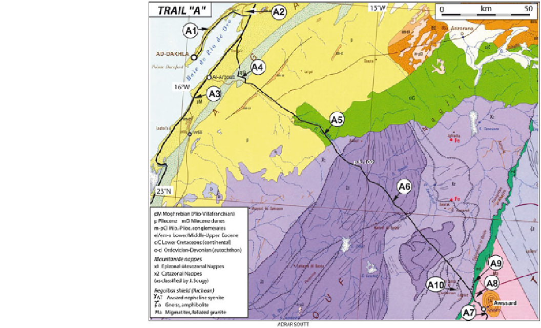
3.1
Dakhla
-
Awsard Geotrail
The geotrail
from Dakhla to Awsard is a rather lengthy
trail (270 km) across Saharan desert landscapes. Most of the
related geosites cluster either close to Dakhla or to Awsard,
with only two geosites in the medium part of the trail (Fig.
3
).
“
A
”
3.1.1 Dakhla Geosites
Geosite A1
is located at the edge of the scenic cliffs formed
by the marine
(Plio-Quaternary) calcarenites
along the oceanic side of the peninsula that form a barrier to
“
Moghrebian
”
Fig. 3
Route and geosites
location of the geoheritage trail
“
A
”
, plotted on the Geological
map of Morocco (Hollard et al.
1985
)