Geology Reference
In-Depth Information
local surface processes such as weathering, erosion and
sedimentation and, at microscale, diagenesis, crystal defects
and deformation, amongst others. This perspective de
In contrast, the term
“
geosite
”
is used to refer to a small
location that has been identi
ed as having geological attri-
butes but has not been allocated special signi
ni-
tively places many aspects of geology, perhaps previously
not recognised as part of the spectrum of geoheritage (Brocx
and Semeniuk
2007
).
Sites of geoheritage signi
cance. In this
paper, most of the identi
ed geosites are, in fact, SSSI.
Geoconservation of geological ensembles involves pres-
ervation of areas that contain a range of signi
cant geolog-
ical features. Geological ensembles can be viewed as a suite
of inter-related SSSI occurring in the same area.
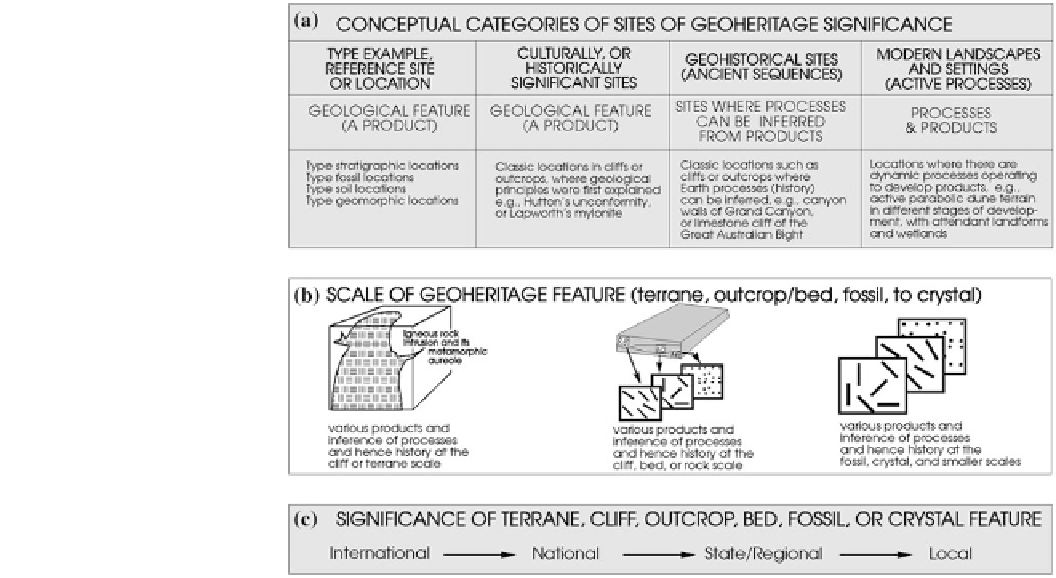
Globally, a geopark is de
cance can be assigned to one of
four categories (Brocx
2008
; Fig.
1
). Scale is important to
consider in geoheritage/geoconservation since features of
signi
ned as a territory encompassing
cance can range from crystals, bedding planes and
outcrops, to that of landscapes and phenomena at montane-
scale. In many locations, sites are important because of
crystal-sized features and crystal fabrics, and it is often at
this scale that the story of Earth unfolds. At the next scale,
features of geoheritage signi
one or more sites of scienti
c importance, not only for geo-
logical reasons but also by virtue of its archaeological, eco-
logical or cultural value. The European Geoparks Network,
established in 2000 (Zouros
2000
)de
nes a geopark as an area
to conserve and valorise geological heritage through an inte-
grated and sustainable development of their territories. The
Asia Pacic Geoparks Network, founded in 2007, dened a
geopark as a nationally-protected area containing a number of
geological heritage sites of particular importance, rarity or
aesthetic appeal. These Earth heritage sites are part of an
integrated concept of protection, education and sustainable
development. The African Geoparks Network created by the
African Association of Women in Geosciences in 2009
(Errami et al.
2012a
,
b
)de
cance are represented by out-
crops and bedding scale features. Important geological/
geomorphological features continue to occur in increasing
scale, up to the scale of mountain ranges, extensive land-
forms, and major drainage basins. Scales and levels of sig-
ni
cance assigned to geoheritage are given in Figs.
2
and
3
.
Geoconservation involves preservation of speci
c sites
(special sites), or of geological ensembles. The former is
where a signi
cant geological feature occurs in isolation, or
may have historical or cultural signi
nes a geopark as an area where
geoheritage could be used as a tool to enhance human sus-
tainable development. All these initiatives aim to protect ge-
odiversity, promote geological heritage, and to support local
sustainable
cance. The term SSSI
(Bowen et al.
1996
) refers to a small or isolated site that has
special signi
cance. The encompassing local geology of
these features may not be signi
cant nationally or regionally.
economic
development,
thus
involving
Fig. 1
The essentials of
geoheritage (Brocx
2008
).
a
The
four categories of sites of
geoheritage signi
cance.
b
The
use of scale.
c
Designating a level
of signi
cance