Geology Reference
In-Depth Information
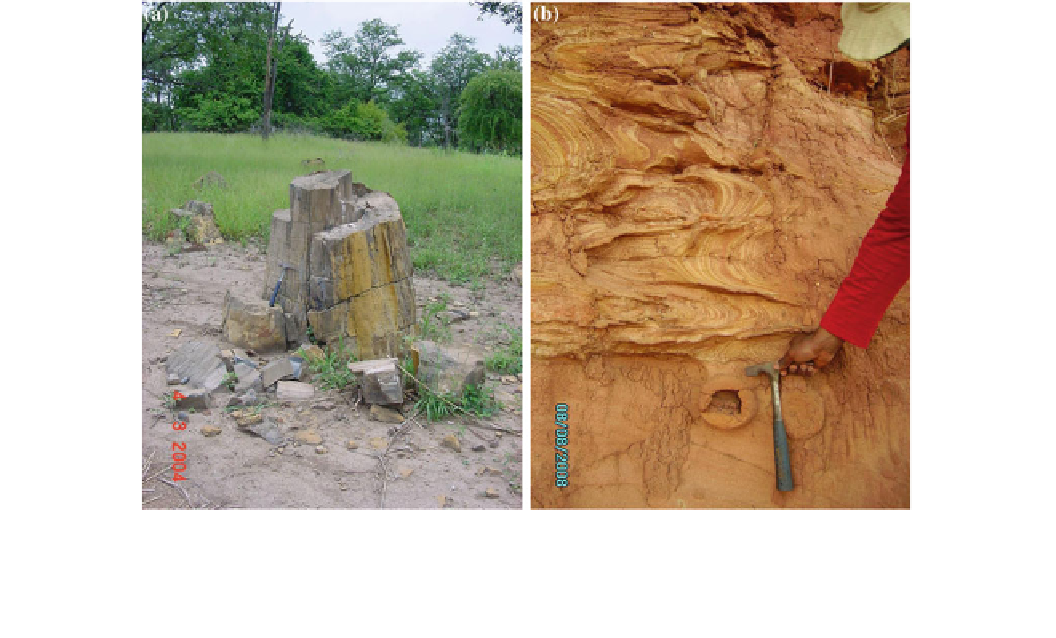
Fig. 14 a
The Chitima Fossil Forest (Carangache area) has an area of
about 18 km
2
(6
the type location is near the railway bridge south of Boane village (at
the coordinates 26
3km
2
) and contains a high concentration of laying
silicied trunks, with a maximum length of 17 m (the unearthed part)
with diameters varying up to 0.80 m (Ferrara
2004
).
b
The Boane
Formation occurs in small polygons in the southern Mozambique, and
×
E). The outcrop is a cliff of
ca 20 m high, composed of ferruginous siltstones and sandstones. The
image
shows cross-bedding and slumping structures. The age is
supposed to be Paleocene (GTK
2006
)
°
3
′
8.44
″
S/32
°
19
′
34.95
″
With such a long geological history, the resulting inten-
sive tectonism, fractures, folds and shears have brought up
scenic waterfalls, (about 15 of them have been identi
Other geomorphic based sites such as the sandstone
Ogbunike caves of about 200 m in length in the south east,
the Osun grove, which had since been declared a World
Heritage site since 2006, is also a remarkable archaeological/
geomorphic geosite. This site is developed around the
mythical Osun river, a tributary of the River Niger with its
grove like forest and scenic stone carvings made more
popular by the late Austrian artist Susan Wenger.
Rock paintings sites dating back to about 20,000 years are
also being developed in the Birni kudu rocks of kebbi state.
Efforts are being made through statutory declarations of
the Tourism acts to preserve and promote these geosites as
the Government at different levels are getting aware of the
social cultural and importantly the economic bene
ed) in
all the six geopolitical zones with the most famous being the
55 m Assop falls near Jos plateau in central plateau area,
Erin Ijesa in the south west (45 m), the Arinja falls (50 m)
also in the south west.
The fractured controlled Ikogosi heritage sites where the
unique warm and cold spring
owing convergently, meets at
a spot creating a luke warm spring that had been judged
medicinal by the locals. It is a unique geosciences heritage
that had been developed and designated into a park. Where
world class chalets, roads and even a natural water bottling
rm had been established attracting tourists and developing
the economy of the local community immensely.
A similar one is also in the Bauchi (Yankari) park in the
north western parts where the warm springs had served as a
swimming and medicinal water bath for tourists. This had
also been developed in addition to the diversi
ts of
these sites by the Governments at different levels. The main
challenge is the political will to implement the statutes
designated for the preservation and promotion of the sites.
The Nigerian geological Survey agency has commenced
making concrete attempts to compile and study these
potential sites with a view to promoting and preserving them.
ed games that
had made it a compulsory geo and games reserve park.
The famous con
uence of the river Niger which has
ve African countries and the Benue River at
Lokoja is also a developing geosite. This con
owed through
3.8
Jordan
uence is
arguably the biggest con
uence of rivers in the West African
sub region creating a
at scenic inland beach that is unique.
The State government of Kogi state had been developing the
site into a full geoheritage sites complete with tourist chalets
boat ways and annual regatta.
Jordan has varied and rich geological and geomorphic fea-
tures (Allan
2012
). It has the lowest point on the earth at
—
400 m below the sea surface (Jica and Mota 1996). It also
has a high quality, varied and abundant biodiversity. Most