Geology Reference
In-Depth Information
2
The Becher Point Cuspate Foreland
and Its Wetlands—Background
Information
been designated as Wetlands of International Importance, and
listed for protection under the Ramsar Convention for their
outstanding scienti
c values as unusual coastal wetlands
(Semeniuk
2007
). In contrast to other wetlands globally,
which usually are large and
The Becher Point Cuspate Foreland in coastal south-western
Australia is a Holocene triangular accretionary sandy deposit
formed leeward of nearshore limestone reefs (Fig.
1
). It is
underlain by a shoaling sequence comprising carbonate and
quartz sand formed in seagrass bank to beach to beachridge
environments (Semeniuk et al.
1988
). Its history began circa
6,000 years ago. With accretion of prograded shore-parallel
beach ridges it formed a coastal plain up to 10 km wide. The
beach ridges alternating with inter-ridge swales record cycles
of ocean storminess and climate changes reflected in their
type, height, and spacing (Semeniuk
1995
,
2007
). The
beachridge plain is underlain by a shallow, uncon
lled with water or habitat for
rare
ora and internationally migratory birds or rare fauna,
the Becher Point wetlands are small basins, colonised by
coastal herbs, sedges and shrubs, and support a local popu-
lation of marsupials and reptiles but with no rare taxa.
The progradation of the beach ridges means that landward
(eastward) parts of the plain are circa 6,000 years old, and
seaward (westward) parts are <1,000 years old, or modern. In
its progradational history, the plain has experienced pro-
gressive climate change from mid- to-late-Holocene, forced
by Earth-axis Precession, with relative aridity changing to
humidity, and has recorded cyclic changes in ocean climate
on 250-year cycles and 45-year cycles (Semeniuk
1995
). The
former had effects on sand composition, calcrete develop-
ment, diagenesis, and soil development, graded across the
plain, while both are re
fl
ned
freshwater body and, with progradation, the water table
inland of the strandline has progressively naturally risen such
that, in time, inter-ridge swales have become waterlogged
then inundated and, set in a carbonate sand stratigraphy, the
wetlands are
ected in large beach ridges
versus
small beach ridges (Semeniuk
1995
). With a rising water
fl
lling with carbonate mud. The wetlands have
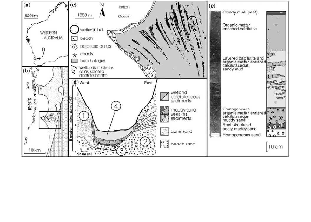
Fig. 1
The Becher Point Cuspate Foreland South-Western Australia
and details of its wetlands (modi
ed from Semeniuk
2007
).
a
Location
in South-Western Australia.
b
Location of the wetlands (
black
)in
parallel array across the beach-ridge plain (
stippled
) and the location of
inset
C in the southern part of the twin cuspate foreland.
c
Location of
the wetlands (
black
) in parallel array across the beach-ridge plain, and
location of wetland 161 towards the eastern (
oldest
) part of the plain.
d
Stratigraphy of basin 161 showing (
1
) dune sand overlying (
2
) beach
sand, (
3
) evidence of dissolution and subsidence, and (
4
) sequence of
sedimentary
ll of muddy sand, calcilutite, and organic matter enriched
calcilutite; the elevation of the contact between beach sand and dune
sand has subsided under the wetland, and the more pronounced
dissolution on the basal western side of the wetland where groundwater
plumes have further dissolved the carbonate of the underlying
sediments.
e
Core from basin 161 showing more detailed three-layered
stratigraphy with a
lowermost
muddy sand, a middle section of
interlayered calcilutite and organic matter enriched calcilutite, and an
uppermost
section of organic matter enriched calcilutite