Geology Reference
In-Depth Information
Fig. 9
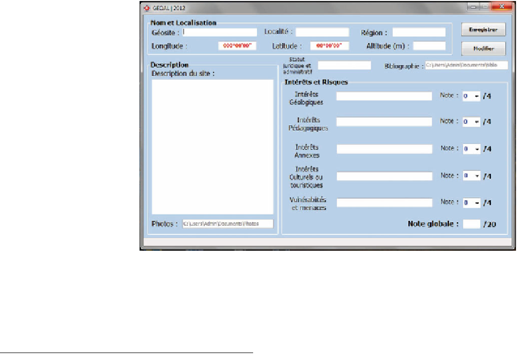
Graphic user interface of
GeoAl database
north-west of El Kantara;
these formations are Triassic
attributes were selected as de
ned in the BRGM models
outcrops (diapirs).
As mentioned previously, this list is not exhaustive. Other
historical geosites exist in Algeria, such as the old Roman
mines, dinosaur tracks (Chabou et al.
2015
), etc.
(BRGM
2007
).
While there is an existing database that lists current
geosites, the GeoAl database allows scope for the user to
add new geosites and information on those geosites. When
a user adds a new geosite,
ne its geo-
graphic coordinates (longitude, latitude, altitude). Thus,
each geosite will be located, described in terms of its
geology, described in terms of its administrative and legal
attributes, and then evaluated based on scienti
they should de
3
GeoAl Project
Some of the natural resources described in this paper are in
danger of irreversible damage and are in urgent need of
protection. For this reason, we initiated project GeoAl to
create software (Fig.
9
) to integrate a database that will be
published free online (see Appendix 1).
The objectives of the GeoAl project are to index and
classify the maximum number of geosites that will be pub-
lished online. This database will be collaborative: other
research groups can bring their contributions online. This
database and the website will be interactive, continually
updated, and enhanced gradually with the progress of the
inventory.
The database will be posted on the website for public
access. The users will have access to the entire geological
map of Algeria with all the information concerning the
geosites listed in the inventory, including photos and avail-
able scienti
c, aesthetic,
educational and legal criteria. Consequently, the goal is to
make the most remarkable geosites known according to a
set of objective criteria. For each region, experts will be
assigned to act as local adjudicators. Among the prioritised
pre-selected geosites, priority will be given to potentially
sensitive sites where information is lacking. Their insertion
into the database provides them with some visibility to
attract
the
attention of government
and educational
institutions.
To select and describe these geosites, the following
methods have been adopted in order to bene
t from the
experiences made in a number of countries (e.g. BRGM
2007
; Fuertes-Gutierrez and Fernandez-Martinez
2010
;
Joyce
2010
). Thus:
1. Name of the geosite, e.g., Greenstones bassin of Alouki,
carbonatites of Ihouhaouene.
2. Name of the region where the geosites are located, e.g.,
In Ouzzal (for Carbonatites of Ihouhaouene).
3. The location of the sites: geographical and administra-
tive boundaries;
4. Description of the site;
c literature. The database thus is an effective
decision-making tool for national geoconservation pro-
grammes and for the identi
cation of areas with high geo-
logical potential to be protected and valorised.
The structure of the GeoAl is centered on 22 attributes
within the database which form the speci
c and pertinent
information to use with every geosite in Algeria. These